Padabeunghar geodata
Padabeunghar (West Java) is a seat of a fourth-order administrative division; located in Indonesia in Asia/Jakarta (GMT+7) time zone. In our database, there are 407 cities with bigger population. Compared to other cities in Indonesia, 64.9% of cities are located further ↓South; 86.3% of cities are located further →East and 70.7% of cities have lower elevation than Padabeunghar. Note1


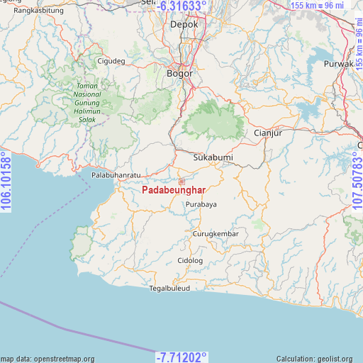
Padabeunghar GPS coordinates[2]
7° 0' 52.92" South, 106° 48' 16.92" East
| Map corner | latitude | longitude |
|---|---|---|
| Upper-left | -6.31633°, | 106.10158° |
| Center: | -7.0147°, | 106.8047° |
| Lower-right: | -7.71202°, | 107.50783° |
| Map W x H: | 155.2×155.2 km | = 96.4×96.4mi |
| max Lat: | 5.88969° ⇑35.1% North |
| Padabeunghar: | -7.0147° |
| min Lat: | ⇓64.9% South -10.934° |
| min Long | Padabeunghar | max Long |
| 95.1345° | 106.8047° | 140.9419° |
| W 13.7%⇐ | ⇒86.3% E |
Elevation
Elevation of Padabeunghar is 301 m = 988 ft, and this is 71.3 m = 234 ft above average elevation for this country.
| Max E: |
3185 m = 10449 ft | 29.3% |
| Padabeunghar | 301 m 988 ft | |
| Avg. | 229.7 m = 754 ft | |
Min E: |
-1 m = -3 ft | 70.7% |
See also: Indonesia elevation on elevation.city.
Geographical zone
Padabeunghar is located in South Torrid zone (between Equator and Tropic of Capricorn). Distance of Equator is 780 km =484.7 mi to North.| Distance of | km | miles | from Padabeunghar |
|---|---|---|---|
| Equator | 780 | 484.7 | to North |
| Tropic Capricorn | 1826 | 1134.6 | to South |
| Antarctic Circle | 6621.2 | 4114.2 | to South |
| South Pole | 9227.1 | 5733.5 | to South |


Nearby cities:
15 places around Padabeunghar: (largest is in red/bold)
• Bojongduren
5.3 km =3.3 mi,  162°
162°
• Bojongjengkol
9.7 km =6 mi,  206°
206°
• Ciareuy
1.7 km =1.1 mi,  193°
193°
• Ciguna
6.6 km =4.1 mi,  169°
169°
• Cilandak
9.8 km =6.1 mi,  280°
280°
• Cipesing
10.9 km =6.8 mi,  114°
114°
• Ciroyom
10.6 km =6.6 mi, 157°
• Gunungkalong
2.2 km =1.4 mi,  341°
341°
• Jampang Tengah
4.7 km =2.9 mi,  184°
184°
• Nangerang
10.6 km =6.6 mi, 183°
• Pasirlaja
7.4 km =4.6 mi,  123°
123°
• Puncakdago
10.9 km =6.8 mi,  217°
217°
• Rancagadog
11.1 km =6.9 mi,  271°
271°
• Sukamaju
9.1 km =5.7 mi,  83°
83°
• Suryabakti
4 km =2.5 mi,  86°
86°
Sources, notices
• [Note1] Compared only with cities in Indonesia existing in our database
• [Src1] Map data: © OpenStreetMap contributors (CC-BY-SA)
• [Src2] Other city data from geonames.org with taken over terms of usage.
• [Src3] Geographical zone / Annual Mean Temperature by Robert A. Rohde @ Wikipedia
