Sukamaju geodata
Sukamaju (West Java) is a seat of a fourth-order administrative division; located in Indonesia in Asia/Jakarta (GMT+7) time zone. In our database, there are 407 cities with bigger population. Compared to other cities in Indonesia, 65.6% of cities are located further ↓South; 86% of cities are located further →East and 81.6% of cities have lower elevation than Sukamaju. Note1


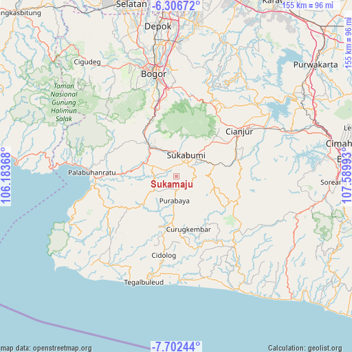
Sukamaju GPS coordinates[2]
7° 0' 18.36" South, 106° 53' 12.48" East
| Map corner | latitude | longitude |
|---|---|---|
| Upper-left | -6.30672°, | 106.18368° |
| Center: | -7.0051°, | 106.8868° |
| Lower-right: | -7.70244°, | 107.58993° |
| Map W x H: | 155.2×155.2 km | = 96.4×96.4mi |
| max Lat: | 5.88969° ⇑34.4% North |
| Sukamaju: | -7.0051° |
| min Lat: | ⇓65.6% South -10.934° |
| min Long | Sukamaju | max Long |
| 95.1345° | 106.8868° | 140.9419° |
| W 14%⇐ | ⇒86% E |
Elevation
Elevation of Sukamaju is 455 m = 1493 ft, and this is 225.3 m = 739 ft above average elevation for this country.
| Max E: |
3185 m = 10449 ft | 18.4% |
| Sukamaju | 455 m 1493 ft | |
| Avg. | 229.7 m = 754 ft | |
Min E: |
-1 m = -3 ft | 81.6% |
See also: Indonesia elevation on elevation.city.
Geographical zone
Sukamaju is located in South Torrid zone (between Equator and Tropic of Capricorn). Distance of Equator is 778.9 km =484 mi to North.| Distance of | km | miles | from Sukamaju |
|---|---|---|---|
| Equator | 778.9 | 484 | to North |
| Tropic Capricorn | 1827 | 1135.2 | to South |
| Antarctic Circle | 6622.3 | 4114.9 | to South |
| South Pole | 9228.2 | 5734.1 | to South |


Nearby cities:
15 places around Sukamaju: (largest is in red/bold)
• Bojongduren
9.7 km =6 mi,  230°
230°
• Ciareuy
9.8 km =6.1 mi,  254°
254°
• Cigawir
8.3 km =5.2 mi,  171°
171°
• Ciguna
10.9 km =6.8 mi, 226°
• Cipesing
5.7 km =3.5 mi, 171°
• Cisantri
7.1 km =4.4 mi,  151°
151°
• Gunungkalong
9.8 km =6.1 mi,  275°
275°
• Legok
7.7 km =4.8 mi,  101°
101°
• Liunggunung
6.2 km =3.9 mi,  117°
117°
• Nyalindung
7.6 km =4.7 mi, 123°
• Padabeunghar
9.1 km =5.7 mi,  263°
263°
• Pasirlaja
6 km =3.7 mi,  209°
209°
• Purabaya
10.6 km =6.6 mi,  183°
183°
• Sukabumi
10.6 km =6.6 mi,  24°
24°
• Suryabakti
5.1 km =3.2 mi, 260°
Sources, notices
• [Note1] Compared only with cities in Indonesia existing in our database
• [Src1] Map data: © OpenStreetMap contributors (CC-BY-SA)
• [Src2] Other city data from geonames.org with taken over terms of usage.
• [Src3] Geographical zone / Annual Mean Temperature by Robert A. Rohde @ Wikipedia
