Ngawi geodata
Ngawi (West Java) is a populated place; located in Indonesia in Asia/Jakarta (GMT+7) time zone. With population of 22,412 people, there are 368 cities with bigger population in this country. Compared to other cities in Indonesia, 53.3% of cities are located further ↑North; 59.3% of cities are located further →East and 60.6% of cities have higher elevation than Ngawi. Note1


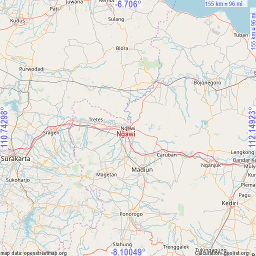
Ngawi GPS coordinates[2]
7° 24' 13.68" South, 111° 26' 45.96" East
| Map corner | latitude | longitude |
|---|---|---|
| Upper-left | -6.706°, | 110.74298° |
| Center: | -7.4038°, | 111.4461° |
| Lower-right: | -8.10049°, | 112.14923° |
| Map W x H: | 155.1×155.1 km | = 96.4×96.4mi |
| max Lat: | 5.88969° ⇑53.3% North |
| Ngawi: | -7.4038° |
| min Lat: | ⇓46.7% South -10.934° |
| min Long | Ngawi | max Long |
| 95.1345° | 111.4461° | 140.9419° |
| W 40.7%⇐ | ⇒59.3% E |
Elevation
Elevation of Ngawi is 57 m = 187 ft, and this is 172.7 m = 567 ft below average elevation for this country.
| Max E: |
3185 m = 10449 ft | 60.6% |
| Avg. | 229.7 m = 754 ft | |
| Ngawi | 57 m = 187 ft | |
Min E: |
-1 m = -3 ft | 39.4% |
See also: Indonesia elevation on elevation.city.
Geographical zone
Ngawi is located in South Torrid zone (between Equator and Tropic of Capricorn). Distance of Equator is 823.2 km =511.5 mi to North.| Distance of | km | miles | from Ngawi |
|---|---|---|---|
| Equator | 823.2 | 511.5 | to North |
| Tropic Capricorn | 1782.7 | 1107.7 | to South |
| Antarctic Circle | 6577.9 | 4087.3 | to South |
| South Pole | 9183.8 | 5706.5 | to South |


Nearby cities:
15 places around Ngawi: (largest is in red/bold)
• Gayam
20.5 km =12.7 mi,  2°
2°
• Gondel
20.1 km =12.5 mi,  15°
15°
• Jetis
22.5 km =14 mi, 20°
• Ketuwan
20.3 km =12.6 mi, 20°
• Menden
17.5 km =10.9 mi, 3°
• Mendenrejo
18.4 km =11.4 mi,  359°
359°
• Mojorejo
19.9 km =12.4 mi, 24°
• Mojorembun
19.9 km =12.4 mi,  7°
7°
• Ngori
21.6 km =13.4 mi,  30°
30°
• Pandan
22.4 km =13.9 mi,  35°
35°
• Panolan
22.1 km =13.7 mi, 25°
• Purwa
22.8 km =14.2 mi, 28°
• Sumberrejo
22.7 km =14.1 mi, 356°
• Tapelan
21.8 km =13.5 mi, 26°
• Temulus
20.8 km =12.9 mi,  352°
352°
Sources, notices
• [Note1] Compared only with cities in Indonesia existing in our database
• [Src1] Map data: © OpenStreetMap contributors (CC-BY-SA)
• [Src2] Other city data from geonames.org with taken over terms of usage.
• [Src3] Geographical zone / Annual Mean Temperature by Robert A. Rohde @ Wikipedia
