Gayam geodata
Gayam (Central Java) is a seat of a fourth-order administrative division; located in Indonesia in Asia/Jakarta (GMT+7) time zone. In our database, there are 407 cities with bigger population. Compared to other cities in Indonesia, 54.1% of cities are located further ↓South; 58.9% of cities are located further →East and 64.8% of cities have higher elevation than Gayam. Note1


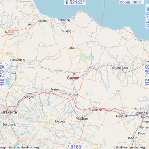
Gayam GPS coordinates[2]
7° 13' 10.2" South, 111° 27' 20.52" East
| Map corner | latitude | longitude |
|---|---|---|
| Upper-left | -6.52143°, | 110.75258° |
| Center: | -7.2195°, | 111.4557° |
| Lower-right: | -7.9165°, | 112.15883° |
| Map W x H: | 155.1×155.1 km | = 96.4×96.4mi |
| max Lat: | 5.88969° ⇑45.9% North |
| Gayam: | -7.2195° |
| min Lat: | ⇓54.1% South -10.934° |
| min Long | Gayam | max Long |
| 95.1345° | 111.4557° | 140.9419° |
| W 41.1%⇐ | ⇒58.9% E |
Elevation
Elevation of Gayam is 43 m = 141 ft, and this is 186.7 m = 613 ft below average elevation for this country.
| Max E: |
3185 m = 10449 ft | 64.8% |
| Avg. | 229.7 m = 754 ft | |
| Gayam | 43 m = 141 ft | |
Min E: |
-1 m = -3 ft | 35.2% |
See also: Indonesia elevation on elevation.city.
Geographical zone
Gayam is located in South Torrid zone (between Equator and Tropic of Capricorn). Distance of Equator is 802.7 km =498.8 mi to North.| Distance of | km | miles | from Gayam |
|---|---|---|---|
| Equator | 802.7 | 498.8 | to North |
| Tropic Capricorn | 1803.2 | 1120.5 | to South |
| Antarctic Circle | 6598.4 | 4100.1 | to South |
| South Pole | 9204.3 | 5719.3 | to South |


Nearby cities:
15 places around Gayam: (largest is in red/bold)
• Gondel
4.4 km =2.7 mi,  104°
104°
• Jetis
6.9 km =4.3 mi,  85°
85°
• Kemantren
7 km =4.3 mi,  80°
80°
• Ketuwan
6.2 km =3.9 mi, 103°
• Menden
3 km =1.9 mi,  181°
181°
• Mendenrejo
2.4 km =1.5 mi,  209°
209°
• Mojorembun
1.8 km =1.1 mi,  116°
116°
• Ngraho
7.1 km =4.4 mi,  40°
40°
• Peting
4.4 km =2.7 mi,  6°
6°
• Ploso Wetan
6 km =3.7 mi,  304°
304°
• Pulo
5.8 km =3.6 mi,  55°
55°
• Sumberrejo
3.2 km =2 mi,  313°
313°
• Tanjung Timur
6 km =3.7 mi,  52°
52°
• Temulus
3.7 km =2.3 mi,  271°
271°
• Wulung
7.1 km =4.4 mi,  294°
294°
Sources, notices
• [Note1] Compared only with cities in Indonesia existing in our database
• [Src1] Map data: © OpenStreetMap contributors (CC-BY-SA)
• [Src2] Other city data from geonames.org with taken over terms of usage.
• [Src3] Geographical zone / Annual Mean Temperature by Robert A. Rohde @ Wikipedia
