Lawang geodata
Lawang (East Java) is a populated place; located in Indonesia in Asia/Jakarta (GMT+7) time zone. With population of 159,380 people, there are 69 cities with bigger population in this country. Compared to other cities in Indonesia, 61% of cities are located further ↑North; 56.9% of cities are located further ←West and 84.5% of cities have lower elevation than Lawang. Note1


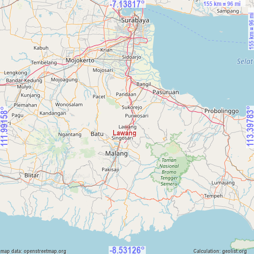
Lawang GPS coordinates[2]
7° 50' 7.08" South, 112° 41' 40.92" East
| Map corner | latitude | longitude |
|---|---|---|
| Upper-left | -7.13817°, | 111.99158° |
| Center: | -7.8353°, | 112.6947° |
| Lower-right: | -8.53126°, | 113.39783° |
| Map W x H: | 154.9×154.9 km | = 96.3×96.3mi |
| max Lat: | 5.88969° ⇑61% North |
| Lawang: | -7.8353° |
| min Lat: | ⇓39% South -10.934° |
| min Long | Lawang | max Long |
| 95.1345° | 112.6947° | 140.9419° |
| W 56.9%⇐ | ⇒43.1% E |
Elevation
Elevation of Lawang is 509 m = 1670 ft, and this is 279.3 m = 916 ft above average elevation for this country.
| Max E: |
3185 m = 10449 ft | 15.5% |
| Lawang | 509 m 1670 ft | |
| Avg. | 229.7 m = 754 ft | |
Min E: |
-1 m = -3 ft | 84.5% |
See also: Lawang elevation on elevation.city.
Geographical zone
Lawang is located in South Torrid zone (between Equator and Tropic of Capricorn). Distance of Equator is 871.2 km =541.3 mi to North.| Distance of | km | miles | from Lawang |
|---|---|---|---|
| Equator | 871.2 | 541.3 | to North |
| Tropic Capricorn | 1734.7 | 1077.9 | to South |
| Antarctic Circle | 6530 | 4057.6 | to South |
| South Pole | 9135.9 | 5676.8 | to South |


Nearby cities:
15 places around Lawang: (largest is in red/bold)
• Batu
18.7 km =11.6 mi,  258°
258°
• Bokor
19.5 km =12.1 mi,  164°
164°
• Bumiayu
21.1 km =13.1 mi,  198°
198°
• Gadang
21 km =13 mi, 200°
• Glagahdowo
20.8 km =12.9 mi,  167°
167°
• Kambingan
19.7 km =12.2 mi,  175°
175°
• Kepuh
20.7 km =12.9 mi, 203°
• Kidal
20.9 km =13 mi, 175°
• Malang
17.5 km =10.9 mi, 203°
• Pandaan
20.3 km =12.6 mi,  357°
357°
• Prigen
19 km =11.8 mi,  333°
333°
• Singosari
7.1 km =4.4 mi,  206°
206°
• Tamiajeng
19.3 km =12 mi, 171°
• Tumpang
20.5 km =12.7 mi, 158°
• Tumpang Satu
20.4 km =12.7 mi, 159°
Sources, notices
• [Note1] Compared only with cities in Indonesia existing in our database
• [Src1] Map data: © OpenStreetMap contributors (CC-BY-SA)
• [Src2] Other city data from geonames.org with taken over terms of usage.
• [Src3] Geographical zone / Annual Mean Temperature by Robert A. Rohde @ Wikipedia
