Kawalu geodata
Kawalu (West Java) is a seat of a third-order administrative division; located in Indonesia in Asia/Jakarta (GMT+7) time zone. With population of 50,541 people, there are 230 cities with bigger population in this country. Compared to other cities in Indonesia, 52.6% of cities are located further ↑North; 76.3% of cities are located further →East and 72.3% of cities have lower elevation than Kawalu. Note1


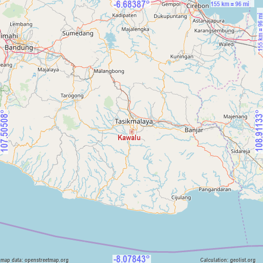
Kawalu GPS coordinates[2]
7° 22' 54.12" South, 108° 12' 29.52" East
| Map corner | latitude | longitude |
|---|---|---|
| Upper-left | -6.68387°, | 107.50508° |
| Center: | -7.3817°, | 108.2082° |
| Lower-right: | -8.07843°, | 108.91133° |
| Map W x H: | 155.1×155.1 km | = 96.4×96.4mi |
| max Lat: | 5.88969° ⇑52.6% North |
| Kawalu: | -7.3817° |
| min Lat: | ⇓47.4% South -10.934° |
| min Long | Kawalu | max Long |
| 95.1345° | 108.2082° | 140.9419° |
| W 23.7%⇐ | ⇒76.3% E |
Elevation
Elevation of Kawalu is 325 m = 1066 ft, and this is 95.3 m = 313 ft above average elevation for this country.
| Max E: |
3185 m = 10449 ft | 27.7% |
| Kawalu | 325 m 1066 ft | |
| Avg. | 229.7 m = 754 ft | |
Min E: |
-1 m = -3 ft | 72.3% |
See also: Kawalu elevation on elevation.city.
Geographical zone
Kawalu is located in South Torrid zone (between Equator and Tropic of Capricorn). Distance of Equator is 820.8 km =510 mi to North.| Distance of | km | miles | from Kawalu |
|---|---|---|---|
| Equator | 820.8 | 510 | to North |
| Tropic Capricorn | 1785.2 | 1109.3 | to South |
| Antarctic Circle | 6580.4 | 4088.9 | to South |
| South Pole | 9186.3 | 5708.1 | to South |


Nearby cities:
15 places around Kawalu: (largest is in red/bold)
• Awilega
1.2 km =0.7 mi,  174°
174°
• Cianjur Kidul
1.5 km =0.9 mi,  135°
135°
• Cibeureum
3 km =1.9 mi,  101°
101°
• Cibeuti
2.2 km =1.4 mi,  256°
256°
• Cigantang Hilir
3.1 km =1.9 mi,  319°
319°
• Citamiang
3.6 km =2.2 mi,  222°
222°
• Gegernoong
2.7 km =1.7 mi, 100°
• Gunungsubang
1.8 km =1.1 mi,  307°
307°
• Pasanggrahan
0.8 km =0.5 mi, 217°
• Rahayu Dua
3.1 km =1.9 mi,  70°
70°
• Sengkol
1.3 km =0.8 mi,  26°
26°
• Sudimara
4 km =2.5 mi,  302°
302°
• Sukagenah
3 km =1.9 mi,  0°
0°
• Sukamaju
2.4 km =1.5 mi,  60°
60°
• Tambir
3.5 km =2.2 mi,  278°
278°
Sources, notices
• [Note1] Compared only with cities in Indonesia existing in our database
• [Src1] Map data: © OpenStreetMap contributors (CC-BY-SA)
• [Src2] Other city data from geonames.org with taken over terms of usage.
• [Src3] Geographical zone / Annual Mean Temperature by Robert A. Rohde @ Wikipedia
