Kapuan geodata
Kapuan (Central Java) is a seat of a fourth-order administrative division; located in Indonesia in Asia/Jakarta (GMT+7) time zone. In our database, there are 407 cities with bigger population. Compared to other cities in Indonesia, 55.6% of cities are located further ↓South; 57% of cities are located further →East and 65.2% of cities have higher elevation than Kapuan. Note1


Kapuan GPS coordinates[2]
7° 11' 21.84" South, 111° 33' 24.12" East
| Map corner | latitude | longitude |
|---|---|---|
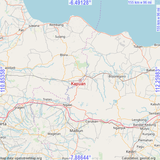
| Upper-left | -6.49128°, | 110.85358° |
| Center: | -7.1894°, | 111.5567° |
| Lower-right: | -7.88644°, | 112.25983° |
| Map W x H: | 155.1×155.1 km | = 96.4×96.4mi |
| max Lat: | 5.88969° ⇑44.4% North |
| Kapuan: | -7.1894° |
| min Lat: | ⇓55.6% South -10.934° |
| min Long | Kapuan | max Long |
| 95.1345° | 111.5567° | 140.9419° |
| W 43%⇐ | ⇒57% E |
Elevation
Elevation of Kapuan is 42 m = 138 ft, and this is 187.7 m = 616 ft below average elevation for this country.
| Max E: |
3185 m = 10449 ft | 65.2% |
| Avg. | 229.7 m = 754 ft | |
| Kapuan | 42 m = 138 ft | |
Min E: |
-1 m = -3 ft | 34.8% |
See also: Indonesia elevation on elevation.city.
Geographical zone
Kapuan is located in South Torrid zone (between Equator and Tropic of Capricorn). Distance of Equator is 799.4 km =496.7 mi to North.| Distance of | km | miles | from Kapuan |
|---|---|---|---|
| Equator | 799.4 | 496.7 | to North |
| Tropic Capricorn | 1806.5 | 1122.5 | to South |
| Antarctic Circle | 6601.8 | 4102.2 | to South |
| South Pole | 9207.7 | 5721.4 | to South |


Nearby cities:
15 places around Kapuan: (largest is in red/bold)
• Kentongan
2.7 km =1.7 mi,  8°
8°
• Ketawang
2.6 km =1.6 mi,  164°
164°
• Klagen
4 km =2.5 mi,  229°
229°
• Mernung
4 km =2.5 mi,  345°
345°
• Mersodo
3.7 km =2.3 mi,  71°
71°
• Mulyorejo
3.5 km =2.2 mi, 14°
• Nglanjuk
4 km =2.5 mi,  50°
50°
• Panolan
4.7 km =2.9 mi,  213°
213°
• Prangi
3 km =1.9 mi,  85°
85°
• Purwa
4 km =2.5 mi,  200°
200°
• Seren
4.2 km =2.6 mi,  329°
329°
• Sugihwaras
1.5 km =0.9 mi,  283°
283°
• Sumberpitu
2.8 km =1.7 mi,  79°
79°
• Tambakkromo
3.9 km =2.4 mi,  22°
22°
• Tebon
1.1 km =0.7 mi, 83°
Sources, notices
• [Note1] Compared only with cities in Indonesia existing in our database
• [Src1] Map data: © OpenStreetMap contributors (CC-BY-SA)
• [Src2] Other city data from geonames.org with taken over terms of usage.
• [Src3] Geographical zone / Annual Mean Temperature by Robert A. Rohde @ Wikipedia
