Gedangan geodata
Gedangan (East Java) is a populated place; located in Indonesia in Asia/Jakarta (GMT+7) time zone. With population of 79,230 people, there are 163 cities with bigger population in this country. Compared to other cities in Indonesia, 52.9% of cities are located further ↑North; 57.2% of cities are located further ←West and 98.5% of cities have higher elevation than Gedangan. Note1


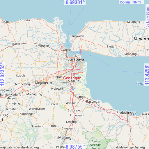
Gedangan GPS coordinates[2]
7° 23' 26.988" South, 112° 43' 36.012" East
| Map corner | latitude | longitude |
|---|---|---|
| Upper-left | -6.69301°, | 112.02355° |
| Center: | -7.39083°, | 112.72667° |
| Lower-right: | -8.08755°, | 113.4298° |
| Map W x H: | 155.1×155.1 km | = 96.4×96.4mi |
| max Lat: | 5.88969° ⇑52.9% North |
| Gedangan: | -7.39083° |
| min Lat: | ⇓47.1% South -10.934° |
| min Long | Gedangan | max Long |
| 95.1345° | 112.72667° | 140.9419° |
| W 57.2%⇐ | ⇒42.8% E |
Elevation
Elevation of Gedangan is 5 m = 16 ft, and this is 224.7 m = 737 ft below average elevation for this country.
| Max E: |
3185 m = 10449 ft | 98.5% |
| Avg. | 229.7 m = 754 ft | |
| Gedangan | 5 m = 16 ft | |
Min E: |
-1 m = -3 ft | 1.5% |
See also: Gedangan elevation on elevation.city.
Geographical zone
Gedangan is located in South Torrid zone (between Equator and Tropic of Capricorn). Distance of Equator is 821.8 km =510.6 mi to North.| Distance of | km | miles | from Gedangan |
|---|---|---|---|
| Equator | 821.8 | 510.6 | to North |
| Tropic Capricorn | 1784.1 | 1108.6 | to South |
| Antarctic Circle | 6579.4 | 4088.2 | to South |
| South Pole | 9185.3 | 5707.5 | to South |


Nearby cities:
15 places around Gedangan: (largest is in red/bold)
• Berbek
6.4 km =4 mi,  39°
39°
• Buduran
4.2 km =2.6 mi,  184°
184°
• Buncitan
6.1 km =3.8 mi,  95°
95°
• Damarsi
4.7 km =2.9 mi,  129°
129°
• Dares
4.6 km =2.9 mi,  58°
58°
• Dukuh Tengah
4.1 km =2.5 mi, 133°
• Pepe
4.9 km =3 mi,  105°
105°
• Sawohan
6.3 km =3.9 mi, 130°
• Sedati
4.5 km =2.8 mi, 96°
• Sedatiagung
3.6 km =2.2 mi,  74°
74°
• Sedatigede
4.2 km =2.6 mi, 68°
• Semampirbarat
5.5 km =3.4 mi, 67°
• Sidoarjo
6.4 km =4 mi,  188°
188°
• Wadungasri
6.9 km =4.3 mi, 42°
• Wedoro
5.2 km =3.2 mi,  31°
31°
Sources, notices
• [Note1] Compared only with cities in Indonesia existing in our database
• [Src1] Map data: © OpenStreetMap contributors (CC-BY-SA)
• [Src2] Other city data from geonames.org with taken over terms of usage.
• [Src3] Geographical zone / Annual Mean Temperature by Robert A. Rohde @ Wikipedia
