Pepe geodata
Pepe (East Java) is a seat of a fourth-order administrative division; located in Indonesia in Asia/Jakarta (GMT+7) time zone. In our database, there are 407 cities with bigger population. Compared to other cities in Indonesia, 53.3% of cities are located further ↑North; 57.6% of cities are located further ←West and 99.1% of cities have higher elevation than Pepe. Note1


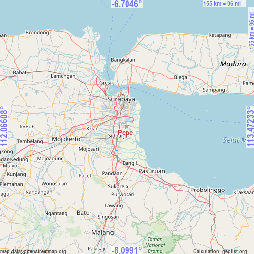
Pepe GPS coordinates[2]
7° 24' 8.64" South, 112° 46' 9.12" East
| Map corner | latitude | longitude |
|---|---|---|
| Upper-left | -6.7046°, | 112.06608° |
| Center: | -7.4024°, | 112.7692° |
| Lower-right: | -8.0991°, | 113.47233° |
| Map W x H: | 155.1×155.1 km | = 96.4×96.4mi |
| max Lat: | 5.88969° ⇑53.3% North |
| Pepe: | -7.4024° |
| min Lat: | ⇓46.7% South -10.934° |
| min Long | Pepe | max Long |
| 95.1345° | 112.7692° | 140.9419° |
| W 57.6%⇐ | ⇒42.4% E |
Elevation
Elevation of Pepe is 4 m = 13 ft, and this is 225.7 m = 740 ft below average elevation for this country.
| Max E: |
3185 m = 10449 ft | 99.1% |
| Avg. | 229.7 m = 754 ft | |
| Pepe | 4 m = 13 ft | |
Min E: |
-1 m = -3 ft | 0.9% |
See also: Indonesia elevation on elevation.city.
Geographical zone
Pepe is located in South Torrid zone (between Equator and Tropic of Capricorn). Distance of Equator is 823.1 km =511.5 mi to North.| Distance of | km | miles | from Pepe |
|---|---|---|---|
| Equator | 823.1 | 511.5 | to North |
| Tropic Capricorn | 1782.8 | 1107.8 | to South |
| Antarctic Circle | 6578.1 | 4087.4 | to South |
| South Pole | 9184 | 5706.7 | to South |


Nearby cities:
15 places around Pepe: (largest is in red/bold)
• Banjarkemuning
4.7 km =2.9 mi,  68°
68°
• Buduran
5.8 km =3.6 mi,  240°
240°
• Buncitan
1.5 km =0.9 mi,  62°
62°
• Damarsi
2 km =1.2 mi,  211°
211°
• Dares
3.8 km =2.4 mi,  348°
348°
• Dukuh Tengah
2.3 km =1.4 mi,  228°
228°
• Dukuhgisikcemandi
4.4 km =2.7 mi, 71°
• Gedangan
4.9 km =3 mi,  285°
285°
• Kalanganyartambak
2.7 km =1.7 mi,  83°
83°
• Sawohan
2.8 km =1.7 mi,  177°
177°
• Sedati
0.8 km =0.5 mi, 346°
• Sedatiagung
2.6 km =1.6 mi,  331°
331°
• Sedatigede
2.9 km =1.8 mi, 345°
• Segorotambak
5.8 km =3.6 mi,  46°
46°
• Semampirbarat
3.4 km =2.1 mi,  6°
6°
Sources, notices
• [Note1] Compared only with cities in Indonesia existing in our database
• [Src1] Map data: © OpenStreetMap contributors (CC-BY-SA)
• [Src2] Other city data from geonames.org with taken over terms of usage.
• [Src3] Geographical zone / Annual Mean Temperature by Robert A. Rohde @ Wikipedia
