Driyorejo geodata
Driyorejo (East Java) is a populated place; located in Indonesia in Asia/Jakarta (GMT+7) time zone. With population of 26,827 people, there are 341 cities with bigger population in this country. Compared to other cities in Indonesia, 52% of cities are located further ↑North; 56.2% of cities are located further ←West and 86.4% of cities have higher elevation than Driyorejo. Note1


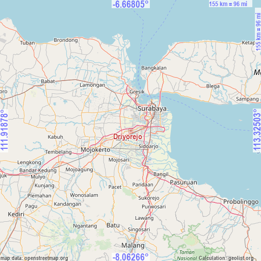
Driyorejo GPS coordinates[2]
7° 21' 57.24" South, 112° 37' 18.84" East
| Map corner | latitude | longitude |
|---|---|---|
| Upper-left | -6.66805°, | 111.91878° |
| Center: | -7.3659°, | 112.6219° |
| Lower-right: | -8.06266°, | 113.32503° |
| Map W x H: | 155.1×155.1 km | = 96.4×96.4mi |
| max Lat: | 5.88969° ⇑52% North |
| Driyorejo: | -7.3659° |
| min Lat: | ⇓48% South -10.934° |
| min Long | Driyorejo | max Long |
| 95.1345° | 112.6219° | 140.9419° |
| W 56.2%⇐ | ⇒43.8% E |
Elevation
Elevation of Driyorejo is 13 m = 43 ft, and this is 216.7 m = 711 ft below average elevation for this country.
| Max E: |
3185 m = 10449 ft | 86.4% |
| Avg. | 229.7 m = 754 ft | |
| Driyorejo | 13 m = 43 ft | |
Min E: |
-1 m = -3 ft | 13.6% |
See also: Indonesia elevation on elevation.city.
Geographical zone
Driyorejo is located in South Torrid zone (between Equator and Tropic of Capricorn). Distance of Equator is 819 km =508.9 mi to North.| Distance of | km | miles | from Driyorejo |
|---|---|---|---|
| Equator | 819 | 508.9 | to North |
| Tropic Capricorn | 1786.9 | 1110.3 | to South |
| Antarctic Circle | 6582.2 | 4090 | to South |
| South Pole | 9188.1 | 5709.2 | to South |


Nearby cities:
15 places around Driyorejo: (largest is in red/bold)
• Berbek
15.8 km =9.8 mi,  82°
82°
• Buduran
13.2 km =8.2 mi,  121°
121°
• Damarsi
16.3 km =10.1 mi,  110°
110°
• Dares
15.5 km =9.6 mi,  91°
91°
• Dukuh Tengah
15.6 km =9.7 mi, 110°
• Gedangan
11.9 km =7.4 mi,  103°
103°
• Jagirsidosermo
16 km =9.9 mi,  65°
65°
• Krian
6.8 km =4.2 mi,  223°
223°
• Prapen
15.9 km =9.9 mi, 68°
• Sedatiagung
15.1 km =9.4 mi, 96°
• Sedatigede
15.5 km =9.6 mi, 94°
• Sidoarjo
14 km =8.7 mi,  130°
130°
• Tulangan Utara
12.4 km =7.7 mi,  165°
165°
• Wadungasri
16.3 km =10.1 mi, 81°
• Wedoro
14.4 km =8.9 mi, 83°
Sources, notices
• [Note1] Compared only with cities in Indonesia existing in our database
• [Src1] Map data: © OpenStreetMap contributors (CC-BY-SA)
• [Src2] Other city data from geonames.org with taken over terms of usage.
• [Src3] Geographical zone / Annual Mean Temperature by Robert A. Rohde @ Wikipedia
