Boyolangu geodata
Boyolangu (East Java) is a seat of a third-order administrative division; located in Indonesia in Asia/Jakarta (GMT+7) time zone. With population of 32,287 people, there are 304 cities with bigger population in this country. Compared to other cities in Indonesia, 66.5% of cities are located further ↑North; 51.5% of cities are located further →East and 52.3% of cities have higher elevation than Boyolangu. Note1


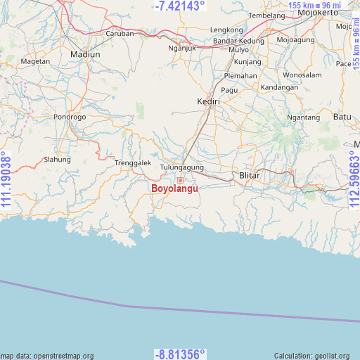
Boyolangu GPS coordinates[2]
8° 7' 5.16" South, 111° 53' 36.6" East
| Map corner | latitude | longitude |
|---|---|---|
| Upper-left | -7.42143°, | 111.19038° |
| Center: | -8.1181°, | 111.8935° |
| Lower-right: | -8.81356°, | 112.59663° |
| Map W x H: | 154.8×154.8 km | = 96.2×96.2mi |
| max Lat: | 5.88969° ⇑66.5% North |
| Boyolangu: | -8.1181° |
| min Lat: | ⇓33.5% South -10.934° |
| min Long | Boyolangu | max Long |
| 95.1345° | 111.8935° | 140.9419° |
| W 48.5%⇐ | ⇒51.5% E |
Elevation
Elevation of Boyolangu is 94 m = 308 ft, and this is 135.7 m = 445 ft below average elevation for this country.
| Max E: |
3185 m = 10449 ft | 52.3% |
| Avg. | 229.7 m = 754 ft | |
| Boyolangu | 94 m = 308 ft | |
Min E: |
-1 m = -3 ft | 47.7% |
See also: Indonesia elevation on elevation.city.
Geographical zone
Boyolangu is located in South Torrid zone (between Equator and Tropic of Capricorn). Distance of Equator is 902.6 km =560.8 mi to North.| Distance of | km | miles | from Boyolangu |
|---|---|---|---|
| Equator | 902.6 | 560.8 | to North |
| Tropic Capricorn | 1703.3 | 1058.4 | to South |
| Antarctic Circle | 6498.5 | 4038 | to South |
| South Pole | 9104.4 | 5657.2 | to South |


Nearby cities:
15 places around Boyolangu: (largest is in red/bold)
• Bayanan
2.7 km =1.7 mi,  51°
51°
• Blimbing
1.2 km =0.7 mi,  238°
238°
• Genting
1 km =0.6 mi,  263°
263°
• Gesikan
3.4 km =2.1 mi,  250°
250°
• Glodokan
2.1 km =1.3 mi,  118°
118°
• Karanggayam
2.8 km =1.7 mi,  44°
44°
• Kedungsinggil
3.2 km =2 mi, 49°
• Mojo
3 km =1.9 mi,  90°
90°
• Ngipik
2.5 km =1.6 mi,  310°
310°
• Pojok
2.6 km =1.6 mi,  181°
181°
• Pucung Kidul
1.2 km =0.7 mi,  104°
104°
• Sanggrahan Kidul
2.4 km =1.5 mi, 97°
• Tanggung
1.6 km =1 mi,  197°
197°
• Temenggungan
3.4 km =2.1 mi,  296°
296°
• Wajak
2.6 km =1.6 mi,  66°
66°
Sources, notices
• [Note1] Compared only with cities in Indonesia existing in our database
• [Src1] Map data: © OpenStreetMap contributors (CC-BY-SA)
• [Src2] Other city data from geonames.org with taken over terms of usage.
• [Src3] Geographical zone / Annual Mean Temperature by Robert A. Rohde @ Wikipedia
