Banyuates geodata
Banyuates (East Java) is a seat of a third-order administrative division; located in Indonesia in Asia/Jakarta (GMT+7) time zone. In our database, there are 407 cities with bigger population. Compared to other cities in Indonesia, 72.9% of cities are located further ↓South; 59.6% of cities are located further ←West and 83% of cities have higher elevation than Banyuates. Note1


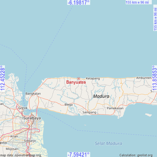
Banyuates GPS coordinates[2]
6° 53' 48.12" South, 113° 9' 19.44" East
| Map corner | latitude | longitude |
|---|---|---|
| Upper-left | -6.19817°, | 112.45228° |
| Center: | -6.8967°, | 113.1554° |
| Lower-right: | -7.59421°, | 113.85853° |
| Map W x H: | 155.2×155.2 km | = 96.4×96.4mi |
| max Lat: | 5.88969° ⇑27.1% North |
| Banyuates: | -6.8967° |
| min Lat: | ⇓72.9% South -10.934° |
| min Long | Banyuates | max Long |
| 95.1345° | 113.1554° | 140.9419° |
| W 59.6%⇐ | ⇒40.4% E |
Elevation
Elevation of Banyuates is 16 m = 52 ft, and this is 213.7 m = 701 ft below average elevation for this country.
| Max E: |
3185 m = 10449 ft | 83% |
| Avg. | 229.7 m = 754 ft | |
| Banyuates | 16 m = 52 ft | |
Min E: |
-1 m = -3 ft | 17% |
See also: Indonesia elevation on elevation.city.
Geographical zone
Banyuates is located in South Torrid zone (between Equator and Tropic of Capricorn). Distance of Equator is 766.8 km =476.5 mi to North.| Distance of | km | miles | from Banyuates |
|---|---|---|---|
| Equator | 766.8 | 476.5 | to North |
| Tropic Capricorn | 1839.1 | 1142.8 | to South |
| Antarctic Circle | 6634.3 | 4122.4 | to South |
| South Pole | 9240.2 | 5741.6 | to South |


Nearby cities:
15 places around Banyuates: (largest is in red/bold)
• Kapasan
3.4 km =2.1 mi,  95°
95°
• Korbukor
5.1 km =3.2 mi,  125°
125°
• Lobuk
3.5 km =2.2 mi,  274°
274°
• Mandeman Daya
0.4 km =0.2 mi,  161°
161°
• Minian
2.8 km =1.7 mi,  220°
220°
• Morbatoh
2.5 km =1.6 mi,  152°
152°
• Nepa
6.4 km =4 mi,  89°
89°
• Pandian
2.5 km =1.6 mi,  208°
208°
• Ramaram
1.7 km =1.1 mi, 95°
• Sembung
0.7 km =0.4 mi,  299°
299°
• Tanahmerah
5.7 km =3.5 mi,  253°
253°
• Tapaan Timur
6.3 km =3.9 mi,  171°
171°
• Tebanah
6.1 km =3.8 mi,  116°
116°
• Tiara
5.4 km =3.4 mi, 205°
• Tlagah Timur
6.7 km =4.2 mi,  108°
108°
Sources, notices
• [Note1] Compared only with cities in Indonesia existing in our database
• [Src1] Map data: © OpenStreetMap contributors (CC-BY-SA)
• [Src2] Other city data from geonames.org with taken over terms of usage.
• [Src3] Geographical zone / Annual Mean Temperature by Robert A. Rohde @ Wikipedia
