Nepa geodata
Nepa (East Java) is a seat of a fourth-order administrative division; located in Indonesia in Asia/Jakarta (GMT+7) time zone. In our database, there are 407 cities with bigger population. Compared to other cities in Indonesia, 72.9% of cities are located further ↓South; 60.1% of cities are located further ←West and 92.1% of cities have higher elevation than Nepa. Note1


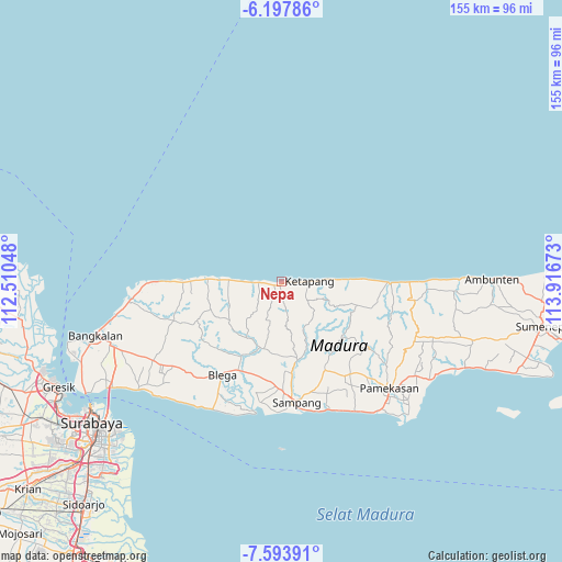
Nepa GPS coordinates[2]
6° 53' 47.04" South, 113° 12' 48.96" East
| Map corner | latitude | longitude |
|---|---|---|
| Upper-left | -6.19786°, | 112.51048° |
| Center: | -6.8964°, | 113.2136° |
| Lower-right: | -7.59391°, | 113.91673° |
| Map W x H: | 155.2×155.2 km | = 96.4×96.4mi |
| max Lat: | 5.88969° ⇑27.1% North |
| Nepa: | -6.8964° |
| min Lat: | ⇓72.9% South -10.934° |
| min Long | Nepa | max Long |
| 95.1345° | 113.2136° | 140.9419° |
| W 60.1%⇐ | ⇒39.9% E |
Elevation
Elevation of Nepa is 9 m = 30 ft, and this is 220.7 m = 724 ft below average elevation for this country.
| Max E: |
3185 m = 10449 ft | 92.1% |
| Avg. | 229.7 m = 754 ft | |
| Nepa | 9 m = 30 ft | |
Min E: |
-1 m = -3 ft | 7.9% |
See also: Indonesia elevation on elevation.city.
Geographical zone
Nepa is located in South Torrid zone (between Equator and Tropic of Capricorn). Distance of Equator is 766.8 km =476.5 mi to North.| Distance of | km | miles | from Nepa |
|---|---|---|---|
| Equator | 766.8 | 476.5 | to North |
| Tropic Capricorn | 1839.1 | 1142.8 | to South |
| Antarctic Circle | 6634.4 | 4122.4 | to South |
| South Pole | 9240.3 | 5741.7 | to South |


Nearby cities:
15 places around Nepa: (largest is in red/bold)
• Banyuates
6.4 km =4 mi,  269°
269°
• Dampol
4.6 km =2.9 mi,  114°
114°
• Kapasan
3.1 km =1.9 mi,  263°
263°
• Korbukor
3.8 km =2.4 mi,  217°
217°
• Mandeman Daya
6.3 km =3.9 mi, 266°
• Masaran
2.7 km =1.7 mi,  129°
129°
• Morbatoh
5.7 km =3.5 mi,  246°
246°
• Pajung
3.6 km =2.2 mi,  93°
93°
• Ramaram
4.8 km =3 mi, 267°
• Sebegen
6.4 km =4 mi,  206°
206°
• Sembung
7 km =4.3 mi, 272°
• Sorren Daya
6.1 km =3.8 mi,  119°
119°
• Sumberbakti
6.6 km =4.1 mi, 89°
• Tebanah
3 km =1.9 mi,  200°
200°
• Tlagah Timur
2.1 km =1.3 mi,  182°
182°
Sources, notices
• [Note1] Compared only with cities in Indonesia existing in our database
• [Src1] Map data: © OpenStreetMap contributors (CC-BY-SA)
• [Src2] Other city data from geonames.org with taken over terms of usage.
• [Src3] Geographical zone / Annual Mean Temperature by Robert A. Rohde @ Wikipedia
