Banjar geodata
Banjar (Bali) is a populated place; located in Indonesia in Asia/Makassar (GMT+8) time zone. With population of 89,040 people, there are 146 cities with bigger population in this country. Compared to other cities in Indonesia, 71% of cities are located further ↑North; 70.6% of cities are located further ←West and 84.2% of cities have higher elevation than Banjar. Note1


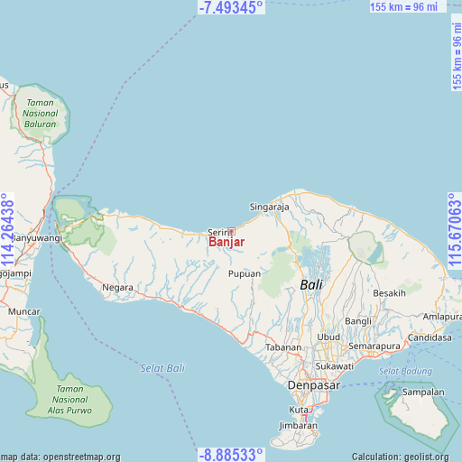
Banjar GPS coordinates[2]
8° 11' 24" South, 114° 58' 3" East
| Map corner | latitude | longitude |
|---|---|---|
| Upper-left | -7.49345°, | 114.26438° |
| Center: | -8.19°, | 114.9675° |
| Lower-right: | -8.88533°, | 115.67063° |
| Map W x H: | 154.8×154.8 km | = 96.2×96.2mi |
| max Lat: | 5.88969° ⇑71% North |
| Banjar: | -8.19° |
| min Lat: | ⇓29% South -10.934° |
| min Long | Banjar | max Long |
| 95.1345° | 114.9675° | 140.9419° |
| W 70.6%⇐ | ⇒29.4% E |
Elevation
Elevation of Banjar is 15 m = 49 ft, and this is 214.7 m = 704 ft below average elevation for this country.
| Max E: |
3185 m = 10449 ft | 84.2% |
| Avg. | 229.7 m = 754 ft | |
| Banjar | 15 m = 49 ft | |
Min E: |
-1 m = -3 ft | 15.8% |
See also: Banjar elevation on elevation.city.
Geographical zone
Banjar is located in South Torrid zone (between Equator and Tropic of Capricorn). Distance of Equator is 910.6 km =565.8 mi to North.| Distance of | km | miles | from Banjar |
|---|---|---|---|
| Equator | 910.6 | 565.8 | to North |
| Tropic Capricorn | 1695.3 | 1053.4 | to South |
| Antarctic Circle | 6490.5 | 4033 | to South |
| South Pole | 9096.4 | 5652.2 | to South |


Nearby cities:
15 places around Banjar: (largest is in red/bold)
• Ambian
1.1 km =0.7 mi,  173°
173°
• Banjar Cempaga
5.9 km =3.7 mi,  126°
126°
• Banjar Dawan
1.5 km =0.9 mi,  219°
219°
• Dajanpura
4.4 km =2.7 mi, 134°
• Kajanan
4.5 km =2.8 mi, 221°
• Kelodan
2.1 km =1.3 mi,  226°
226°
• Kertanadi
5.2 km =3.2 mi,  201°
201°
• Mayong
6.1 km =3.8 mi,  185°
185°
• Pegayaman
2.3 km =1.4 mi,  71°
71°
• Purwa
4.2 km =2.6 mi,  273°
273°
• Seririt
3.2 km =2 mi,  264°
264°
• Tamansari
2.6 km =1.6 mi,  254°
254°
• Tampekan
1.5 km =0.9 mi,  154°
154°
• Tangguwisia
2.5 km =1.6 mi, 249°
• Umbanyar
5.5 km =3.4 mi, 264°
Sources, notices
• [Note1] Compared only with cities in Indonesia existing in our database
• [Src1] Map data: © OpenStreetMap contributors (CC-BY-SA)
• [Src2] Other city data from geonames.org with taken over terms of usage.
• [Src3] Geographical zone / Annual Mean Temperature by Robert A. Rohde @ Wikipedia
