Purwa geodata
Purwa (Bali) is a seat of a fourth-order administrative division; located in Indonesia in Asia/Makassar (GMT+8) time zone. In our database, there are 407 cities with bigger population. Compared to other cities in Indonesia, 70.9% of cities are located further ↑North; 70.4% of cities are located further ←West and 86.4% of cities have higher elevation than Purwa. Note1


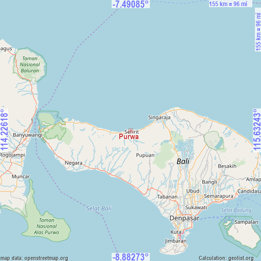
Purwa GPS coordinates[2]
8° 11' 14.64" South, 114° 55' 45.48" East
| Map corner | latitude | longitude |
|---|---|---|
| Upper-left | -7.49085°, | 114.22618° |
| Center: | -8.1874°, | 114.9293° |
| Lower-right: | -8.88273°, | 115.63243° |
| Map W x H: | 154.8×154.8 km | = 96.2×96.2mi |
| max Lat: | 5.88969° ⇑70.9% North |
| Purwa: | -8.1874° |
| min Lat: | ⇓29.1% South -10.934° |
| min Long | Purwa | max Long |
| 95.1345° | 114.9293° | 140.9419° |
| W 70.4%⇐ | ⇒29.6% E |
Elevation
Elevation of Purwa is 13 m = 43 ft, and this is 216.7 m = 711 ft below average elevation for this country.
| Max E: |
3185 m = 10449 ft | 86.4% |
| Avg. | 229.7 m = 754 ft | |
| Purwa | 13 m = 43 ft | |
Min E: |
-1 m = -3 ft | 13.6% |
See also: Indonesia elevation on elevation.city.
Geographical zone
Purwa is located in South Torrid zone (between Equator and Tropic of Capricorn). Distance of Equator is 910.4 km =565.7 mi to North.| Distance of | km | miles | from Purwa |
|---|---|---|---|
| Equator | 910.4 | 565.7 | to North |
| Tropic Capricorn | 1695.6 | 1053.6 | to South |
| Antarctic Circle | 6490.8 | 4033.2 | to South |
| South Pole | 9096.7 | 5652.4 | to South |


Nearby cities:
15 places around Purwa: (largest is in red/bold)
• Ambian
4.6 km =2.9 mi,  107°
107°
• Banjar
4.2 km =2.6 mi,  93°
93°
• Banjar Dawan
3.6 km =2.2 mi, 113°
• Dajanrurung
4.6 km =2.9 mi,  250°
250°
• Kajanan
3.8 km =2.4 mi,  160°
160°
• Kelodan
3.2 km =2 mi,  123°
123°
• Kertanadi
5.7 km =3.5 mi, 155°
• Pangkungparuk
5.6 km =3.5 mi,  236°
236°
• Pegayaman
6.4 km =4 mi, 86°
• Seririt
1.2 km =0.7 mi, 119°
• Tamansari
1.9 km =1.2 mi, 120°
• Tampekan
5.1 km =3.2 mi, 108°
• Tangguwisia
2.2 km =1.4 mi, 120°
• Umbanyar
1.5 km =0.9 mi, 236°
• Yatnyaketi
5.5 km =3.4 mi,  179°
179°
Sources, notices
• [Note1] Compared only with cities in Indonesia existing in our database
• [Src1] Map data: © OpenStreetMap contributors (CC-BY-SA)
• [Src2] Other city data from geonames.org with taken over terms of usage.
• [Src3] Geographical zone / Annual Mean Temperature by Robert A. Rohde @ Wikipedia
