Portraine geodata
Portraine (Leinster) is a populated place; located in Ireland in Europe/Dublin (GMT+1) time zone. With population of 1,372 people, there are 288 cities with bigger population in this country. Compared to other cities in Ireland, 71.5% of cities are located further ↓South; 97.2% of cities are located further ←West and 99.1% of cities have higher elevation than Portraine. Note1


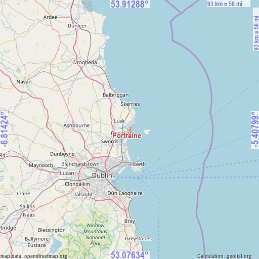
Portraine GPS coordinates[2]
53° 29' 48.012" North, 6° 6' 39.996" West
| Map corner | latitude | longitude |
|---|---|---|
| Upper-left | 53.91288°, | -6.81424° |
| Center: | 53.49667°, | -6.11111° |
| Lower-right: | 53.07634°, | -5.40799° |
| Map W x H: | 93×93 km | = 57.8×57.8mi |
| max Lat: | 55.25° ⇑28.5% North |
| Portraine: | 53.49667° |
| min Lat: | ⇓71.5% South 51.52487° |
| min Long | Portraine | max Long |
| -10.26889° | -6.11111° | -6.04944° |
| W 97.2%⇐ | ⇒2.8% E |
Elevation
Elevation of Portraine is 3 m = 10 ft, and this is 51.5 m = 169 ft below average elevation for this country.
| Max E: |
262 m = 860 ft | 99.1% |
| Avg. | 54.5 m = 179 ft | |
| Portraine | 3 m = 10 ft | |
Min E: |
0 m = 0 ft | 0.9% |
See also: Ireland elevation on elevation.city.
Geographical zone
Portraine is located in North temperate zone (between Tropic of Cancer and the Arctic Circle). Distance of this North polar circle is 1452.9 km =902.8 mi to North.| Distance of | km | miles | from Portraine |
|---|---|---|---|
| North Pole | 4058.8 | 2522 | to North |
| Arctic Circle | 1452.9 | 902.8 | to North |
| Tropic Cancer | 3342.4 | 2076.9 | to South |
| Equator | 5948.3 | 3696.1 | to South |


Nearby cities:
15 places around Portraine: (largest is in red/bold)
• An Ros
3.1 km =1.9 mi,  7°
7°
• Baldoyle
10.8 km =6.7 mi,  185°
185°
• Balrothery
11.4 km =7.1 mi,  333°
333°
• Bayside
12.1 km =7.5 mi, 189°
• Darndale
12 km =7.5 mi,  205°
205°
• Donabate
2.9 km =1.8 mi,  248°
248°
• Donaghmede
11.4 km =7.1 mi,  197°
197°
• Kinsealy-Drinan
8.5 km =5.3 mi,  226°
226°
• Loughshinny
6.1 km =3.8 mi,  17°
17°
• Lusk
4.9 km =3 mi,  314°
314°
• Malahide
5.8 km =3.6 mi, 209°
• Portmarnock
8.4 km =5.2 mi, 192°
• Skerries
9.6 km =6 mi,  1°
1°
• Sutton
11.9 km =7.4 mi,  179°
179°
• Swords
8.2 km =5.1 mi,  239°
239°
Sources, notices
• [Note1] Compared only with cities in Ireland existing in our database
• [Src1] Map data: © OpenStreetMap contributors (CC-BY-SA)
• [Src2] Other city data from geonames.org with taken over terms of usage.
• [Src3] Geographical zone / Annual Mean Temperature by Robert A. Rohde @ Wikipedia
