Swords geodata
Swords (Leinster) is a seat of a first-order administrative division; located in Ireland in Europe/Dublin (GMT+1) time zone. With population of 36,924 people, there are 7 cities with bigger population in this country. Compared to other cities in Ireland, 70.2% of cities are located further ↓South; 89.8% of cities are located further ←West and 80.5% of cities have higher elevation than Swords. Note1


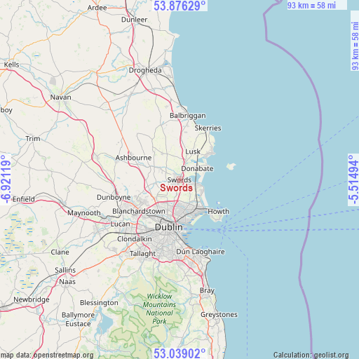
Swords GPS coordinates[2]
53° 27' 34.992" North, 6° 13' 5.016" West
| Map corner | latitude | longitude |
|---|---|---|
| Upper-left | 53.87629°, | -6.92119° |
| Center: | 53.45972°, | -6.21806° |
| Lower-right: | 53.03902°, | -5.51494° |
| Map W x H: | 93.1×93.1 km | = 57.8×57.8mi |
| max Lat: | 55.25° ⇑29.8% North |
| Swords: | 53.45972° |
| min Lat: | ⇓70.2% South 51.52487° |
| min Long | Swords | max Long |
| -10.26889° | -6.21806° | -6.04944° |
| W 89.8%⇐ | ⇒10.2% E |
Elevation
Elevation of Swords is 17 m = 56 ft, and this is 37.5 m = 123 ft below average elevation for this country.
| Max E: |
262 m = 860 ft | 80.5% |
| Avg. | 54.5 m = 179 ft | |
| Swords | 17 m = 56 ft | |
Min E: |
0 m = 0 ft | 19.5% |
See also: Ireland elevation on elevation.city.
Geographical zone
Swords is located in North temperate zone (between Tropic of Cancer and the Arctic Circle). Distance of this North polar circle is 1457 km =905.3 mi to North.| Distance of | km | miles | from Swords |
|---|---|---|---|
| North Pole | 4062.9 | 2524.6 | to North |
| Arctic Circle | 1457 | 905.3 | to North |
| Tropic Cancer | 3338.2 | 2074.3 | to South |
| Equator | 5944.2 | 3693.6 | to South |


Nearby cities:
15 places around Swords: (largest is in red/bold)
• Artane
8.1 km =5 mi,  177°
177°
• Ballymun
7.6 km =4.7 mi,  205°
205°
• Beaumont
8.1 km =5 mi, 184°
• Bonnybrook
6.9 km =4.3 mi,  174°
174°
• Coolock
8 km =5 mi, 171°
• Darndale
7 km =4.3 mi,  163°
163°
• Donabate
5.3 km =3.3 mi,  55°
55°
• Donaghmede
7.8 km =4.8 mi,  151°
151°
• Kinsealy-Drinan
2 km =1.2 mi, 150°
• Lusk
8.3 km =5.2 mi,  25°
25°
• Malahide
4.3 km =2.7 mi,  103°
103°
• Portmarnock
6.7 km =4.2 mi,  127°
127°
• Portraine
8.2 km =5.1 mi, 59°
• Raheny
8.5 km =5.3 mi, 163°
• Rivermeade
4.9 km =3 mi,  261°
261°
Sources, notices
• [Note1] Compared only with cities in Ireland existing in our database
• [Src1] Map data: © OpenStreetMap contributors (CC-BY-SA)
• [Src2] Other city data from geonames.org with taken over terms of usage.
• [Src3] Geographical zone / Annual Mean Temperature by Robert A. Rohde @ Wikipedia
