Nof Ayalon geodata
Nof Ayalon (Central District) is a populated place; located in Israel in Asia/Jerusalem (GMT+3) time zone. With population of 5,000 people, there are 109 cities with bigger population in this country. Compared to other cities in Israel, 80.5% of cities are located further ↑North; 58.6% of cities are located further →East and 59.8% of cities have lower elevation than Nof Ayalon. Note1


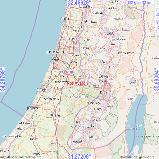
Nof Ayalon GPS coordinates[2]
31° 52' 15.996" North, 34° 59' 26.916" East
| Map corner | latitude | longitude |
|---|---|---|
| Upper-left | 32.46629°, | 34.28769° |
| Center: | 31.87111°, | 34.99081° |
| Lower-right: | 31.27206°, | 35.69394° |
| Map W x H: | 132.8×132.8 km | = 82.5×82.5mi |
| max Lat: | 33.27918° ⇑80.5% North |
| Nof Ayalon: | 31.87111° |
| min Lat: | ⇓19.5% South 29.55805° |
| min Long | Nof Ayalon | max Long |
| 34.57149° | 34.99081° | 35.81084° |
| W 41.4%⇐ | ⇒58.6% E |
Elevation
Elevation of Nof Ayalon is 204 m = 669 ft, and this is 19.4 m = 64 ft below average elevation for this country.
| Max E: |
988 m = 3241 ft | 40.2% |
| Avg. | 223.4 m = 733 ft | |
| Nof Ayalon | 204 m = 669 ft | |
Min E: |
-380 m = -1247 ft | 59.8% |
See also: Israel elevation on elevation.city.
Geographical zone
Nof Ayalon is located in North temperate zone (between Tropic of Cancer and the Arctic Circle). Distance of this Northern Tropic circle is 937.8 km =582.7 mi to South.| Distance of | km | miles | from Nof Ayalon |
|---|---|---|---|
| North Pole | 6463.3 | 4016.1 | to North |
| Arctic Circle | 3857.4 | 2396.9 | to North |
| Tropic Cancer | 937.8 | 582.7 | to South |
| Equator | 3543.7 | 2202 | to South |


Nearby cities:
15 places around Nof Ayalon: (largest is in red/bold)
• Abū Ghaush
13.3 km =8.3 mi,  122°
122°
• Beit Horon
13.2 km =8.2 mi,  87°
87°
• Dolev
14.8 km =9.2 mi,  65°
65°
• Har Adar
14.1 km =8.8 mi,  110°
110°
• Hashmonaim
7.1 km =4.4 mi,  23°
23°
• Kfar NaOranim
6.9 km =4.3 mi,  38°
38°
• Lapid
6.5 km =4 mi, 37°
• Lod
12.7 km =7.9 mi,  311°
311°
• Mazkeret Batya
13.8 km =8.6 mi,  261°
261°
• Mevo horon
4.9 km =3 mi, 120°
• Modiin Ilit
8.5 km =5.3 mi, 36°
• Modi‘in Makkabbim Re‘ut
3.4 km =2.1 mi, 42°
• Na'ale
12.4 km =7.7 mi,  34°
34°
• Nili
11.7 km =7.3 mi, 27°
• Ramla
13.5 km =8.4 mi,  298°
298°
Sources, notices
• [Note1] Compared only with cities in Israel existing in our database
• [Src1] Map data: © OpenStreetMap contributors (CC-BY-SA)
• [Src2] Other city data from geonames.org with taken over terms of usage.
• [Src3] Geographical zone / Annual Mean Temperature by Robert A. Rohde @ Wikipedia
