Nadiād geodata
Nadiād (Gujarat) is a populated place; located in India in Asia/Kolkata (GMT+5.5) time zone. With population of 202,067 people, there are 208 cities with bigger population in this country. Compared to other cities in India, 51.1% of cities are located further ↑North; 95.6% of cities are located further →East and 81.9% of cities have higher elevation than Nadiād. Note1


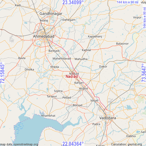
Nadiād GPS coordinates[2]
22° 41' 37.86" North, 72° 51' 41.652" East
| Map corner | latitude | longitude |
|---|---|---|
| Upper-left | 23.34099°, | 72.15845° |
| Center: | 22.69385°, | 72.86157° |
| Lower-right: | 22.04364°, | 73.5647° |
| Map W x H: | 144.3×144.3 km | = 89.7×89.7mi |
| max Lat: | 34.9274° ⇑51.1% North |
| Nadiād: | 22.69385° |
| min Lat: | ⇓48.9% South 8.09008° |
| min Long | Nadiād | max Long |
| 68.82655° | 72.86157° | 96.81° |
| W 4.4%⇐ | ⇒95.6% E |
Elevation
Elevation of Nadiād is 41 m = 135 ft, and this is 254.6 m = 835 ft below average elevation for this country.
| Max E: |
3681 m = 12077 ft | 81.9% |
| Avg. | 295.6 m = 970 ft | |
| Nadiād | 41 m = 135 ft | |
Min E: |
1 m = 3 ft | 18.1% |
See also: Nadiād elevation on elevation.city.
Geographical zone
Nadiād is located in North Torrid zone (between Equator and Tropic of Cancer). Distance of this Northern Tropic circle is 82.6 km =51.3 mi to North.| Distance of | km | miles | from Nadiād |
|---|---|---|---|
| North Pole | 7483.7 | 4650.2 | to North |
| Arctic Circle | 4877.9 | 3031 | to North |
| Tropic Cancer | 82.6 | 51.3 | to North |
| Equator | 2523.3 | 1567.9 | to South |


Nearby cities:
15 places around Nadiād: (largest is in red/bold)
• Anand
18.4 km =11.4 mi,  148°
148°
• Borsad
32 km =19.9 mi,  173°
173°
• Chaklāsi
9.7 km =6 mi,  117°
117°
• Dākor
30.3 km =18.8 mi,  77°
77°
• Kapadvanj
42.4 km =26.3 mi,  30°
30°
• Karamsad
17.4 km =10.8 mi, 165°
• Kheda
19.2 km =11.9 mi,  289°
289°
• Mahemdāvād
18.1 km =11.2 mi,  322°
322°
• Mahudha
16.3 km =10.1 mi, 29°
• Petlād
24.9 km =15.5 mi,  194°
194°
• Sojītra
22.6 km =14 mi,  220°
220°
• Thāsra
37.7 km =23.4 mi,  72°
72°
• Umreth
26.1 km =16.2 mi,  88°
88°
• Vallabh Vidyanagar
18.3 km =11.4 mi, 167°
• Vasa
11.5 km =7.1 mi,  251°
251°
Sources, notices
• [Note1] Compared only with cities in India existing in our database
• [Src1] Map data: © OpenStreetMap contributors (CC-BY-SA)
• [Src2] Other city data from geonames.org with taken over terms of usage.
• [Src3] Geographical zone / Annual Mean Temperature by Robert A. Rohde @ Wikipedia
