Thāsra geodata
Thāsra (Gujarat) is a populated place; located in India in Asia/Kolkata (GMT+5.5) time zone. With population of 18,337 people, there are 2176 cities with bigger population in this country. Compared to other cities in India, 50.1% of cities are located further ↓South; 93.7% of cities are located further →East and 75% of cities have higher elevation than Thāsra. Note1


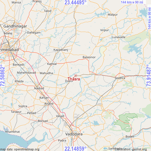
Thāsra GPS coordinates[2]
22° 47' 53.916" North, 73° 12' 42.264" East
| Map corner | latitude | longitude |
|---|---|---|
| Upper-left | 23.44495°, | 72.50862° |
| Center: | 22.79831°, | 73.21174° |
| Lower-right: | 22.14859°, | 73.91487° |
| Map W x H: | 144.1×144.1 km | = 89.5×89.5mi |
| max Lat: | 34.9274° ⇑49.9% North |
| Thāsra: | 22.79831° |
| min Lat: | ⇓50.1% South 8.09008° |
| min Long | Thāsra | max Long |
| 68.82655° | 73.21174° | 96.81° |
| W 6.3%⇐ | ⇒93.7% E |
Elevation
Elevation of Thāsra is 68 m = 223 ft, and this is 227.6 m = 747 ft below average elevation for this country.
| Max E: |
3681 m = 12077 ft | 75% |
| Avg. | 295.6 m = 970 ft | |
| Thāsra | 68 m = 223 ft | |
Min E: |
1 m = 3 ft | 25% |
See also: India elevation on elevation.city.
Geographical zone
Thāsra is located in North Torrid zone (between Equator and Tropic of Cancer). Distance of this Northern Tropic circle is 71 km =44.1 mi to North.| Distance of | km | miles | from Thāsra |
|---|---|---|---|
| North Pole | 7472.1 | 4642.9 | to North |
| Arctic Circle | 4866.2 | 3023.7 | to North |
| Tropic Cancer | 71 | 44.1 | to North |
| Equator | 2534.9 | 1575.1 | to South |


Nearby cities:
15 places around Thāsra: (largest is in red/bold)
• Anand
37.9 km =23.5 mi,  223°
223°
• Chaklāsi
31.8 km =19.8 mi,  239°
239°
• Dākor
8.1 km =5 mi,  231°
231°
• Godhra
41.4 km =25.7 mi,  93°
93°
• Hālol
42.3 km =26.3 mi,  140°
140°
• Kapadvanj
28.8 km =17.9 mi,  330°
330°
• Karamsad
42.5 km =26.4 mi, 227°
• Kālol
33.3 km =20.7 mi,  129°
129°
• Mahemdāvād
46.8 km =29.1 mi,  273°
273°
• Mahudha
27.9 km =17.3 mi,  275°
275°
• Nadiād
37.7 km =23.4 mi,  252°
252°
• Umreth
14.8 km =9.2 mi, 221°
• Vallabh Vidyanagar
43.5 km =27 mi, 227°
• Vasa
49.3 km =30.6 mi, 251°
• Vejalpur
38 km =23.6 mi,  108°
108°
Sources, notices
• [Note1] Compared only with cities in India existing in our database
• [Src1] Map data: © OpenStreetMap contributors (CC-BY-SA)
• [Src2] Other city data from geonames.org with taken over terms of usage.
• [Src3] Geographical zone / Annual Mean Temperature by Robert A. Rohde @ Wikipedia
