Lonavla geodata
Lonavla (Maharashtra) is a populated place; located in India in Asia/Kolkata (GMT+5.5) time zone. With population of 58,562 people, there are 753 cities with bigger population in this country. Compared to other cities in India, 69.5% of cities are located further ↑North; 92.9% of cities are located further →East and 89.8% of cities have lower elevation than Lonavla. Note1


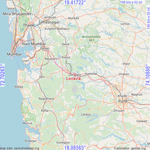
Lonavla GPS coordinates[2]
18° 45' 9.9" North, 73° 24' 20.7" East
| Map corner | latitude | longitude |
|---|---|---|
| Upper-left | 19.41722°, | 72.70263° |
| Center: | 18.75275°, | 73.40575° |
| Lower-right: | 18.08565°, | 74.10888° |
| Map W x H: | 148.1×148.1 km | = 92×92mi |
| max Lat: | 34.9274° ⇑69.5% North |
| Lonavla: | 18.75275° |
| min Lat: | ⇓30.5% South 8.09008° |
| min Long | Lonavla | max Long |
| 68.82655° | 73.40575° | 96.81° |
| W 7.1%⇐ | ⇒92.9% E |
Elevation
Elevation of Lonavla is 631 m = 2070 ft, and this is 335.4 m = 1100 ft above average elevation for this country.
| Max E: |
3681 m = 12077 ft | 10.2% |
| Lonavla | 631 m 2070 ft | |
| Avg. | 295.6 m = 970 ft | |
Min E: |
1 m = 3 ft | 89.8% |
See also: Lonavla elevation on elevation.city.
Geographical zone
Lonavla is located in North Torrid zone (between Equator and Tropic of Cancer). Distance of this Northern Tropic circle is 520.8 km =323.6 mi to North.| Distance of | km | miles | from Lonavla |
|---|---|---|---|
| North Pole | 7922 | 4922.5 | to North |
| Arctic Circle | 5316.1 | 3303.3 | to North |
| Tropic Cancer | 520.8 | 323.6 | to North |
| Equator | 2085.1 | 1295.6 | to South |


Nearby cities:
15 places around Lonavla: (largest is in red/bold)
• Badlapur
47.1 km =29.3 mi,  341°
341°
• Chākan
48.2 km =30 mi,  88°
88°
• Dehu
38.2 km =23.7 mi,  95°
95°
• Karjat
19.6 km =12.2 mi,  333°
333°
• Khopoli
7.3 km =4.5 mi,  300°
300°
• Kālundri
38.7 km =24 mi,  310°
310°
• Mātherān
29.5 km =18.3 mi, 329°
• Neral
31.7 km =19.7 mi, 342°
• Nāgothana
36.9 km =22.9 mi,  230°
230°
• Panvel
40.7 km =25.3 mi, 310°
• Pen
32.7 km =20.3 mi,  266°
266°
• Pimpri
44.7 km =27.8 mi,  108°
108°
• Roha
46.3 km =28.8 mi,  220°
220°
• Talegaon Dābhāde
28.5 km =17.7 mi, 93°
• Wadgaon
24.7 km =15.3 mi, 93°
Sources, notices
• [Note1] Compared only with cities in India existing in our database
• [Src1] Map data: © OpenStreetMap contributors (CC-BY-SA)
• [Src2] Other city data from geonames.org with taken over terms of usage.
• [Src3] Geographical zone / Annual Mean Temperature by Robert A. Rohde @ Wikipedia
