Jodhpur geodata
Jodhpur (Gujarat) is a populated place; located in India in Asia/Kolkata (GMT+5.5) time zone. With population of 47,329 people, there are 934 cities with bigger population in this country. Compared to other cities in India, 57% of cities are located further ↑North; 99.5% of cities are located further →East and 68.7% of cities have higher elevation than Jodhpur. Note1


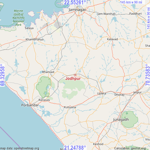
Jodhpur GPS coordinates[2]
21° 54' 6.264" North, 70° 1' 57.72" East
| Map corner | latitude | longitude |
|---|---|---|
| Upper-left | 22.55261°, | 69.32958° |
| Center: | 21.90174°, | 70.0327° |
| Lower-right: | 21.24788°, | 70.73583° |
| Map W x H: | 145.1×145.1 km | = 90.2×90.2mi |
| max Lat: | 34.9274° ⇑57% North |
| Jodhpur: | 21.90174° |
| min Lat: | ⇓43% South 8.09008° |
| min Long | Jodhpur | max Long |
| 68.82655° | 70.0327° | 96.81° |
| W 0.5%⇐ | ⇒99.5% E |
Elevation
Elevation of Jodhpur is 99 m = 325 ft, and this is 196.6 m = 645 ft below average elevation for this country.
| Max E: |
3681 m = 12077 ft | 68.7% |
| Avg. | 295.6 m = 970 ft | |
| Jodhpur | 99 m = 325 ft | |
Min E: |
1 m = 3 ft | 31.3% |
See also: Jodhpur elevation on elevation.city.
Geographical zone
Jodhpur is located in North Torrid zone (between Equator and Tropic of Cancer). Distance of this Northern Tropic circle is 170.7 km =106.1 mi to North.| Distance of | km | miles | from Jodhpur |
|---|---|---|---|
| North Pole | 7571.8 | 4704.9 | to North |
| Arctic Circle | 4965.9 | 3085.7 | to North |
| Tropic Cancer | 170.7 | 106.1 | to North |
| Equator | 2435.2 | 1513.2 | to South |


Nearby cities:
15 places around Jodhpur: (largest is in red/bold)
• Bhānvad
26.2 km =16.3 mi,  277°
277°
• Bhāyāvadar
22.8 km =14.2 mi,  103°
103°
• Bāntva
46.2 km =28.7 mi,  174°
174°
• Dhorāji
47 km =29.2 mi,  113°
113°
• Jetalsar
60.1 km =37.3 mi, 110°
• Jūnāgadh
61.2 km =38 mi,  133°
133°
• Khambhāliya
52 km =32.3 mi,  310°
310°
• Kutiyāna
31.3 km =19.4 mi,  189°
189°
• Kālāvad
49.7 km =30.9 mi,  46°
46°
• Lālpur
32.9 km =20.4 mi,  347°
347°
• Mānāvadar
46.2 km =28.7 mi, 166°
• Porbandar
52.4 km =32.6 mi,  236°
236°
• Rānāvāv
38.1 km =23.7 mi,  231°
231°
• Sikka
62.2 km =38.6 mi,  341°
341°
• Upleta
31.4 km =19.5 mi,  124°
124°
Sources, notices
• [Note1] Compared only with cities in India existing in our database
• [Src1] Map data: © OpenStreetMap contributors (CC-BY-SA)
• [Src2] Other city data from geonames.org with taken over terms of usage.
• [Src3] Geographical zone / Annual Mean Temperature by Robert A. Rohde @ Wikipedia
