Khambhāliya geodata
Khambhāliya (Gujarat) is a seat of a second-order administrative division; located in India in Asia/Kolkata (GMT+5.5) time zone. With population of 38,121 people, there are 1153 cities with bigger population in this country. Compared to other cities in India, 55.2% of cities are located further ↑North; 99.8% of cities are located further →East and 79.4% of cities have higher elevation than Khambhāliya. Note1


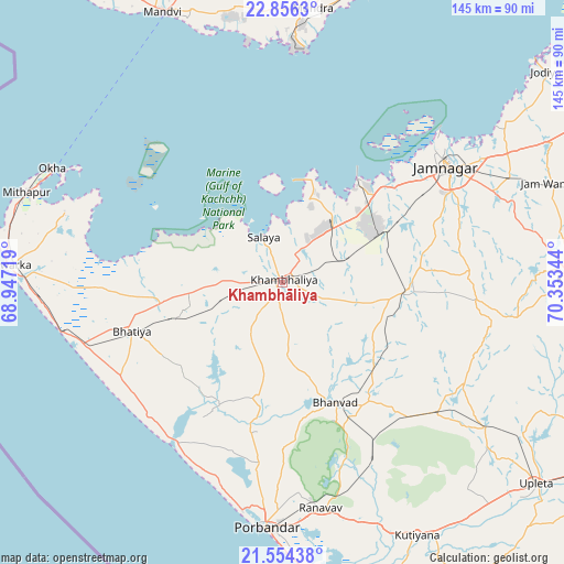
Khambhāliya GPS coordinates[2]
22° 12' 24.66" North, 69° 39' 1.116" East
| Map corner | latitude | longitude |
|---|---|---|
| Upper-left | 22.8563°, | 68.94719° |
| Center: | 22.20685°, | 69.65031° |
| Lower-right: | 21.55438°, | 70.35344° |
| Map W x H: | 144.8×144.8 km | = 90×90mi |
| max Lat: | 34.9274° ⇑55.2% North |
| Khambhāliya: | 22.20685° |
| min Lat: | ⇓44.8% South 8.09008° |
| min Long | Khambhāliya | max Long |
| 68.82655° | 69.65031° | 96.81° |
| W 0.2%⇐ | ⇒99.8% E |
Elevation
Elevation of Khambhāliya is 50 m = 164 ft, and this is 245.6 m = 806 ft below average elevation for this country.
| Max E: |
3681 m = 12077 ft | 79.4% |
| Avg. | 295.6 m = 970 ft | |
| Khambhāliya | 50 m = 164 ft | |
Min E: |
1 m = 3 ft | 20.6% |
See also: India elevation on elevation.city.
Geographical zone
Khambhāliya is located in North Torrid zone (between Equator and Tropic of Cancer). Distance of this Northern Tropic circle is 136.7 km =84.9 mi to North.| Distance of | km | miles | from Khambhāliya |
|---|---|---|---|
| North Pole | 7537.9 | 4683.8 | to North |
| Arctic Circle | 4932 | 3064.6 | to North |
| Tropic Cancer | 136.7 | 84.9 | to North |
| Equator | 2469.2 | 1534.3 | to South |


Nearby cities:
15 places around Khambhāliya: (largest is in red/bold)
• Bedi
52 km =32.3 mi,  50°
50°
• Bhānvad
33.5 km =20.8 mi,  156°
156°
• Bhāyāvadar
73 km =45.4 mi,  122°
122°
• Dwārka
70.3 km =43.7 mi,  272°
272°
• Jamnagar
52.1 km =32.4 mi,  55°
55°
• Jodhpur
52 km =32.3 mi,  130°
130°
• Kutiyāna
73.4 km =45.6 mi,  151°
151°
• Kālāvad
75.5 km =46.9 mi,  89°
89°
• Lālpur
32.3 km =20.1 mi, 93°
• Mundra
70.7 km =43.9 mi,  5°
5°
• Okha
66.3 km =41.2 mi,  295°
295°
• Porbandar
62.9 km =39.1 mi,  183°
183°
• Rānāvāv
58.6 km =36.4 mi,  170°
170°
• Salāya
12.5 km =7.8 mi,  337°
337°
• Sikka
31.9 km =19.8 mi,  38°
38°
Sources, notices
• [Note1] Compared only with cities in India existing in our database
• [Src1] Map data: © OpenStreetMap contributors (CC-BY-SA)
• [Src2] Other city data from geonames.org with taken over terms of usage.
• [Src3] Geographical zone / Annual Mean Temperature by Robert A. Rohde @ Wikipedia
