Bhiwandi geodata
Bhiwandi (Maharashtra) is a populated place; located in India in Asia/Kolkata (GMT+5.5) time zone. With population of 707,035 people, there are 65 cities with bigger population in this country. Compared to other cities in India, 67.5% of cities are located further ↑North; 94.4% of cities are located further →East and 97.4% of cities have higher elevation than Bhiwandi. Note1


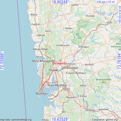
Bhiwandi GPS coordinates[2]
19° 18' 0.828" North, 73° 3' 31.716" East
| Map corner | latitude | longitude |
|---|---|---|
| Upper-left | 19.96248°, | 72.35569° |
| Center: | 19.30023°, | 73.05881° |
| Lower-right: | 18.63529°, | 73.76194° |
| Map W x H: | 147.6×147.6 km | = 91.7×91.7mi |
| max Lat: | 34.9274° ⇑67.5% North |
| Bhiwandi: | 19.30023° |
| min Lat: | ⇓32.5% South 8.09008° |
| min Long | Bhiwandi | max Long |
| 68.82655° | 73.05881° | 96.81° |
| W 5.6%⇐ | ⇒94.4% E |
Elevation
Elevation of Bhiwandi is 9 m = 30 ft, and this is 286.6 m = 940 ft below average elevation for this country.
| Max E: |
3681 m = 12077 ft | 97.4% |
| Avg. | 295.6 m = 970 ft | |
| Bhiwandi | 9 m = 30 ft | |
Min E: |
1 m = 3 ft | 2.6% |
See also: Bhiwandi elevation on elevation.city.
Geographical zone
Bhiwandi is located in North Torrid zone (between Equator and Tropic of Cancer). Distance of this Northern Tropic circle is 459.9 km =285.8 mi to North.| Distance of | km | miles | from Bhiwandi |
|---|---|---|---|
| North Pole | 7861.1 | 4884.7 | to North |
| Arctic Circle | 5255.2 | 3265.4 | to North |
| Tropic Cancer | 459.9 | 285.8 | to North |
| Equator | 2146 | 1333.5 | to South |


Nearby cities:
15 places around Bhiwandi: (largest is in red/bold)
• Airoli
17.8 km =11.1 mi,  201°
201°
• Amarnāth
15.9 km =9.9 mi,  134°
134°
• Artist Village
29.8 km =18.5 mi,  183°
183°
• Badlapur
27 km =16.8 mi, 126°
• Bhayandar
21.8 km =13.5 mi,  270°
270°
• Borivli
22.1 km =13.7 mi,  250°
250°
• Dombivli
9.6 km =6 mi,  164°
164°
• Kalyān
10.2 km =6.3 mi, 127°
• Mumbai
31.3 km =19.4 mi,  216°
216°
• Navi Mumbai
29.6 km =18.4 mi,  188°
188°
• Powai
26.1 km =16.2 mi, 218°
• Thāne
15.2 km =9.4 mi, 221°
• Ulhasnagar
13.3 km =8.3 mi, 134°
• Vasind
24.6 km =15.3 mi,  60°
60°
• Virār
31.2 km =19.4 mi,  303°
303°
Sources, notices
• [Note1] Compared only with cities in India existing in our database
• [Src1] Map data: © OpenStreetMap contributors (CC-BY-SA)
• [Src2] Other city data from geonames.org with taken over terms of usage.
• [Src3] Geographical zone / Annual Mean Temperature by Robert A. Rohde @ Wikipedia
