Virār geodata
Virār (Maharashtra) is a populated place; located in India in Asia/Kolkata (GMT+5.5) time zone. With population of 150,357 people, there are 294 cities with bigger population in this country. Compared to other cities in India, 67% of cities are located further ↑North; 95.9% of cities are located further →East and 97.4% of cities have higher elevation than Virār. Note1


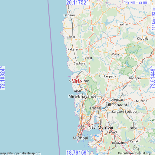
Virār GPS coordinates[2]
19° 27' 21.276" North, 72° 48' 40.896" East
| Map corner | latitude | longitude |
|---|---|---|
| Upper-left | 20.11752°, | 72.10824° |
| Center: | 19.45591°, | 72.81136° |
| Lower-right: | 18.79159°, | 73.51449° |
| Map W x H: | 147.4×147.4 km | = 91.6×91.6mi |
| max Lat: | 34.9274° ⇑67% North |
| Virār: | 19.45591° |
| min Lat: | ⇓33% South 8.09008° |
| min Long | Virār | max Long |
| 68.82655° | 72.81136° | 96.81° |
| W 4.1%⇐ | ⇒95.9% E |
Elevation
Elevation of Virār is 9 m = 30 ft, and this is 286.6 m = 940 ft below average elevation for this country.
| Max E: |
3681 m = 12077 ft | 97.4% |
| Avg. | 295.6 m = 970 ft | |
| Virār | 9 m = 30 ft | |
Min E: |
1 m = 3 ft | 2.6% |
See also: Virār elevation on elevation.city.
Geographical zone
Virār is located in North Torrid zone (between Equator and Tropic of Cancer). Distance of this Northern Tropic circle is 442.6 km =275 mi to North.| Distance of | km | miles | from Virār |
|---|---|---|---|
| North Pole | 7843.8 | 4873.9 | to North |
| Arctic Circle | 5237.9 | 3254.7 | to North |
| Tropic Cancer | 442.6 | 275 | to North |
| Equator | 2163.3 | 1344.2 | to South |


Nearby cities:
15 places around Virār: (largest is in red/bold)
• Airoli
39.1 km =24.3 mi,  150°
150°
• Bhayandar
17.7 km =11 mi,  166°
166°
• Bhiwandi
31.2 km =19.4 mi,  123°
123°
• Boisar
39.1 km =24.3 mi,  351°
351°
• Borivli
25.1 km =15.6 mi, 168°
• Dombivli
39 km =24.2 mi,  132°
132°
• Kalyān
41.4 km =25.7 mi, 124°
• Manor
31.6 km =19.6 mi,  19°
19°
• Mumbai
43.2 km =26.8 mi, 170°
• Powai
39 km =24.2 mi, 165°
• Pālghar
27.2 km =16.9 mi, 349°
• Shirgaon
28.5 km =17.7 mi,  339°
339°
• Thāne
32.9 km =20.4 mi, 150°
• Ulhasnagar
44.4 km =27.6 mi, 126°
• Vāda
41.6 km =25.8 mi,  58°
58°
Sources, notices
• [Note1] Compared only with cities in India existing in our database
• [Src1] Map data: © OpenStreetMap contributors (CC-BY-SA)
• [Src2] Other city data from geonames.org with taken over terms of usage.
• [Src3] Geographical zone / Annual Mean Temperature by Robert A. Rohde @ Wikipedia
