Bandora geodata
Bandora (Goa) is a populated place; located in India in Asia/Kolkata (GMT+5.5) time zone. With population of 12,819 people, there are 2670 cities with bigger population in this country. Compared to other cities in India, 80.2% of cities are located further ↑North; 89.6% of cities are located further →East and 84.4% of cities have higher elevation than Bandora. Note1


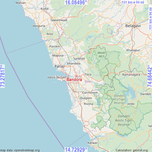
Bandora GPS coordinates[2]
15° 24' 29.628" North, 73° 58' 52.644" East
| Map corner | latitude | longitude |
|---|---|---|
| Upper-left | 16.08496°, | 73.27817° |
| Center: | 15.40823°, | 73.98129° |
| Lower-right: | 14.72929°, | 74.68442° |
| Map W x H: | 150.7×150.7 km | = 93.6×93.6mi |
| max Lat: | 34.9274° ⇑80.2% North |
| Bandora: | 15.40823° |
| min Lat: | ⇓19.8% South 8.09008° |
| min Long | Bandora | max Long |
| 68.82655° | 73.98129° | 96.81° |
| W 10.4%⇐ | ⇒89.6% E |
Elevation
Elevation of Bandora is 32 m = 105 ft, and this is 263.6 m = 865 ft below average elevation for this country.
| Max E: |
3681 m = 12077 ft | 84.4% |
| Avg. | 295.6 m = 970 ft | |
| Bandora | 32 m = 105 ft | |
Min E: |
1 m = 3 ft | 15.6% |
See also: India elevation on elevation.city.
Geographical zone
Bandora is located in North Torrid zone (between Equator and Tropic of Cancer). Distance of this Northern Tropic circle is 892.7 km =554.7 mi to North.| Distance of | km | miles | from Bandora |
|---|---|---|---|
| North Pole | 8293.8 | 5153.5 | to North |
| Arctic Circle | 5687.9 | 3534.3 | to North |
| Tropic Cancer | 892.7 | 554.7 | to North |
| Equator | 1713.2 | 1064.5 | to South |


Nearby cities:
15 places around Bandora: (largest is in red/bold)
• Bambolim
15.1 km =9.4 mi,  294°
294°
• Chicalim
15 km =9.3 mi,  265°
265°
• Colva
15.6 km =9.7 mi,  203°
203°
• Cortalim
7.8 km =4.8 mi, 265°
• Curti
3.9 km =2.4 mi,  76°
76°
• Davorlim
15.2 km =9.4 mi,  175°
175°
• Goa Velha
11 km =6.8 mi, 291°
• Jua
14 km =8.7 mi,  346°
346°
• Madgaon
15 km =9.3 mi,  189°
189°
• Navelim
13.9 km =8.6 mi,  0°
0°
• Palle
12.7 km =7.9 mi,  59°
59°
• Ponda
3.7 km =2.3 mi,  98°
98°
• Queula
2.1 km =1.3 mi,  167°
167°
• Raia
11.5 km =7.1 mi, 185°
• Sancoale
9 km =5.6 mi,  248°
248°
Sources, notices
• [Note1] Compared only with cities in India existing in our database
• [Src1] Map data: © OpenStreetMap contributors (CC-BY-SA)
• [Src2] Other city data from geonames.org with taken over terms of usage.
• [Src3] Geographical zone / Annual Mean Temperature by Robert A. Rohde @ Wikipedia
