Madgaon geodata
Madgaon (Goa) is a populated place; located in India in Asia/Kolkata (GMT+5.5) time zone. With population of 86,818 people, there are 516 cities with bigger population in this country. Compared to other cities in India, 80.9% of cities are located further ↑North; 89.8% of cities are located further →East and 88.1% of cities have higher elevation than Madgaon. Note1


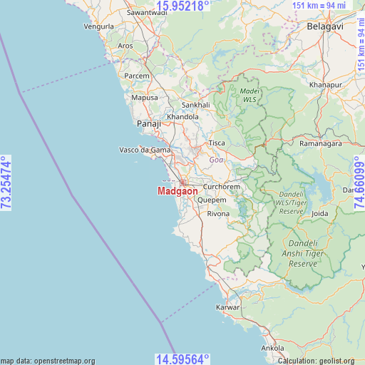
Madgaon GPS coordinates[2]
15° 16' 30.036" North, 73° 57' 28.296" East
| Map corner | latitude | longitude |
|---|---|---|
| Upper-left | 15.95218°, | 73.25474° |
| Center: | 15.27501°, | 73.95786° |
| Lower-right: | 14.59564°, | 74.66099° |
| Map W x H: | 150.8×150.8 km | = 93.7×93.7mi |
| max Lat: | 34.9274° ⇑80.9% North |
| Madgaon: | 15.27501° |
| min Lat: | ⇓19.1% South 8.09008° |
| min Long | Madgaon | max Long |
| 68.82655° | 73.95786° | 96.81° |
| W 10.2%⇐ | ⇒89.8% E |
Elevation
Elevation of Madgaon is 22 m = 72 ft, and this is 273.6 m = 898 ft below average elevation for this country.
| Max E: |
3681 m = 12077 ft | 88.1% |
| Avg. | 295.6 m = 970 ft | |
| Madgaon | 22 m = 72 ft | |
Min E: |
1 m = 3 ft | 11.9% |
See also: Madgaon elevation on elevation.city.
Geographical zone
Madgaon is located in North Torrid zone (between Equator and Tropic of Cancer). Distance of this Northern Tropic circle is 907.5 km =563.9 mi to North.| Distance of | km | miles | from Madgaon |
|---|---|---|---|
| North Pole | 8308.6 | 5162.7 | to North |
| Arctic Circle | 5702.8 | 3543.6 | to North |
| Tropic Cancer | 907.5 | 563.9 | to North |
| Equator | 1698.4 | 1055.3 | to South |


Nearby cities:
15 places around Madgaon: (largest is in red/bold)
• Bandora
15 km =9.3 mi,  9°
9°
• Benaulim
3.4 km =2.1 mi,  249°
249°
• Cavelossim
11.5 km =7.1 mi,  188°
188°
• Chinchinim
7 km =4.3 mi,  164°
164°
• Colva
3.8 km =2.4 mi,  278°
278°
• Cortalim
15.1 km =9.4 mi,  339°
339°
• Cuncolim
11.5 km =7.1 mi, 160°
• Curchorem
16.2 km =10.1 mi,  94°
94°
• Davorlim
3.7 km =2.3 mi, 94°
• Ponda
15.5 km =9.6 mi,  23°
23°
• Quepem
14.6 km =9.1 mi,  118°
118°
• Queula
13.1 km =8.1 mi, 13°
• Raia
3.6 km =2.2 mi, 22°
• Sancoale
12.8 km =8 mi,  333°
333°
• Varca
5 km =3.1 mi,  198°
198°
Sources, notices
• [Note1] Compared only with cities in India existing in our database
• [Src1] Map data: © OpenStreetMap contributors (CC-BY-SA)
• [Src2] Other city data from geonames.org with taken over terms of usage.
• [Src3] Geographical zone / Annual Mean Temperature by Robert A. Rohde @ Wikipedia
