Dumjor geodata
Dumjor (West Bengal) is a populated place; located in India in Asia/Kolkata (GMT+5.5) time zone. With population of 17,972 people, there are 2203 cities with bigger population in this country. Compared to other cities in India, 51.8% of cities are located further ↑North; 92.2% of cities are located further ←West and 96.4% of cities have higher elevation than Dumjor. Note1


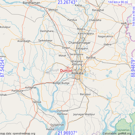
Dumjor GPS coordinates[2]
22° 37' 11.748" North, 88° 14' 44.376" East
| Map corner | latitude | longitude |
|---|---|---|
| Upper-left | 23.26743°, | 87.54254° |
| Center: | 22.61993°, | 88.24566° |
| Lower-right: | 21.96937°, | 88.94879° |
| Map W x H: | 144.3×144.3 km | = 89.7×89.7mi |
| max Lat: | 34.9274° ⇑51.8% North |
| Dumjor: | 22.61993° |
| min Lat: | ⇓48.2% South 8.09008° |
| min Long | Dumjor | max Long |
| 68.82655° | 88.24566° | 96.81° |
| W 92.2%⇐ | ⇒7.8% E |
Elevation
Elevation of Dumjor is 10 m = 33 ft, and this is 285.6 m = 937 ft below average elevation for this country.
| Max E: |
3681 m = 12077 ft | 96.4% |
| Avg. | 295.6 m = 970 ft | |
| Dumjor | 10 m = 33 ft | |
Min E: |
1 m = 3 ft | 3.6% |
See also: India elevation on elevation.city.
Geographical zone
Dumjor is located in North Torrid zone (between Equator and Tropic of Cancer). Distance of this Northern Tropic circle is 90.8 km =56.4 mi to North.| Distance of | km | miles | from Dumjor |
|---|---|---|---|
| North Pole | 7492 | 4655.3 | to North |
| Arctic Circle | 4886.1 | 3036.1 | to North |
| Tropic Cancer | 90.8 | 56.4 | to North |
| Equator | 2515.1 | 1562.8 | to South |


Nearby cities:
15 places around Dumjor: (largest is in red/bold)
• Bankra
3.8 km =2.4 mi,  120°
120°
• Bara Bazar
12.2 km =7.6 mi, 118°
• Begampur
12.4 km =7.7 mi,  5°
5°
• Bhandārdaha
5.5 km =3.4 mi,  264°
264°
• Bāli
10.3 km =6.4 mi,  71°
71°
• Chakapara
10.7 km =6.6 mi,  82°
82°
• Dhulagari
8.7 km =5.4 mi,  241°
241°
• Hāora
8.9 km =5.5 mi, 122°
• Krishnapur
6.1 km =3.8 mi,  23°
23°
• Mahiari
3.7 km =2.3 mi,  196°
196°
• Masila
4.5 km =2.8 mi, 196°
• Parbatipur
5.3 km =3.3 mi,  333°
333°
• Raghudebbati
11.7 km =7.3 mi,  205°
205°
• Santoshpur
11.3 km =7 mi,  167°
167°
• Sānkrāil
8.1 km =5 mi, 195°
Sources, notices
• [Note1] Compared only with cities in India existing in our database
• [Src1] Map data: © OpenStreetMap contributors (CC-BY-SA)
• [Src2] Other city data from geonames.org with taken over terms of usage.
• [Src3] Geographical zone / Annual Mean Temperature by Robert A. Rohde @ Wikipedia
