Chakapara geodata
Chakapara (West Bengal) is a populated place; located in India in Asia/Kolkata (GMT+5.5) time zone. With population of 27,320 people, there are 1573 cities with bigger population in this country. Compared to other cities in India, 51.8% of cities are located further ↑North; 93.1% of cities are located further ←West and 99% of cities have higher elevation than Chakapara. Note1


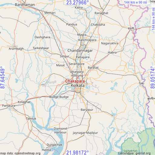
Chakapara GPS coordinates[2]
22° 37' 55.992" North, 88° 20' 54.996" East
| Map corner | latitude | longitude |
|---|---|---|
| Upper-left | 23.27966°, | 87.64549° |
| Center: | 22.63222°, | 88.34861° |
| Lower-right: | 21.98172°, | 89.05174° |
| Map W x H: | 144.3×144.3 km | = 89.7×89.7mi |
| max Lat: | 34.9274° ⇑51.8% North |
| Chakapara: | 22.63222° |
| min Lat: | ⇓48.2% South 8.09008° |
| min Long | Chakapara | max Long |
| 68.82655° | 88.34861° | 96.81° |
| W 93.1%⇐ | ⇒6.9% E |
Elevation
Elevation of Chakapara is 7 m = 23 ft, and this is 288.6 m = 947 ft below average elevation for this country.
| Max E: |
3681 m = 12077 ft | 99% |
| Avg. | 295.6 m = 970 ft | |
| Chakapara | 7 m = 23 ft | |
Min E: |
1 m = 3 ft | 1% |
See also: India elevation on elevation.city.
Geographical zone
Chakapara is located in North Torrid zone (between Equator and Tropic of Cancer). Distance of this Northern Tropic circle is 89.5 km =55.6 mi to North.| Distance of | km | miles | from Chakapara |
|---|---|---|---|
| North Pole | 7490.6 | 4654.4 | to North |
| Arctic Circle | 4884.7 | 3035.2 | to North |
| Tropic Cancer | 89.5 | 55.6 | to North |
| Equator | 2516.5 | 1563.7 | to South |


Nearby cities:
15 places around Chakapara: (largest is in red/bold)
• Bankra
8 km =5 mi,  245°
245°
• Bara Bazar
7.3 km =4.5 mi,  178°
178°
• Baranagar
3.1 km =1.9 mi,  71°
71°
• Bāli
2 km =1.2 mi,  337°
337°
• Dam Dam
7.6 km =4.7 mi,  89°
89°
• Garui
5.3 km =3.3 mi, 88°
• Hāora
6.9 km =4.3 mi,  206°
206°
• Khardah
10.1 km =6.3 mi,  17°
17°
• Kolkata
7.9 km =4.9 mi,  169°
169°
• Konnagar
8.1 km =5 mi,  356°
356°
• Krishnapur
9.2 km =5.7 mi,  297°
297°
• Kāmārhāti
5.1 km =3.2 mi,  31°
31°
• Pānihāti
7 km =4.3 mi, 21°
• Rishra
10.2 km =6.3 mi, 358°
• Sodpur
9.1 km =5.7 mi, 28°
Sources, notices
• [Note1] Compared only with cities in India existing in our database
• [Src1] Map data: © OpenStreetMap contributors (CC-BY-SA)
• [Src2] Other city data from geonames.org with taken over terms of usage.
• [Src3] Geographical zone / Annual Mean Temperature by Robert A. Rohde @ Wikipedia
