Serpur geodata
Serpur (West Bengal) is a populated place; located in India in Asia/Kolkata (GMT+5.5) time zone. With population of 7,936 people, there are 3129 cities with bigger population in this country. Compared to other cities in India, 54.2% of cities are located further ↑North; 92.8% of cities are located further ←West and 98.3% of cities have higher elevation than Serpur. Note1


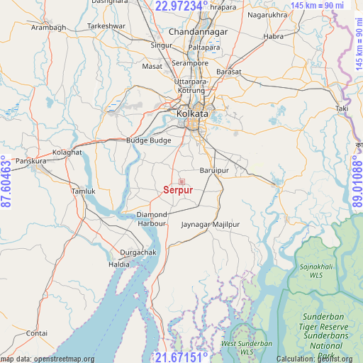
Serpur GPS coordinates[2]
22° 19' 24.384" North, 88° 18' 27.9" East
| Map corner | latitude | longitude |
|---|---|---|
| Upper-left | 22.97234°, | 87.60463° |
| Center: | 22.32344°, | 88.30775° |
| Lower-right: | 21.67151°, | 89.01088° |
| Map W x H: | 144.6×144.6 km | = 89.9×89.9mi |
| max Lat: | 34.9274° ⇑54.2% North |
| Serpur: | 22.32344° |
| min Lat: | ⇓45.8% South 8.09008° |
| min Long | Serpur | max Long |
| 68.82655° | 88.30775° | 96.81° |
| W 92.8%⇐ | ⇒7.2% E |
Elevation
Elevation of Serpur is 8 m = 26 ft, and this is 287.6 m = 944 ft below average elevation for this country.
| Max E: |
3681 m = 12077 ft | 98.3% |
| Avg. | 295.6 m = 970 ft | |
| Serpur | 8 m = 26 ft | |
Min E: |
1 m = 3 ft | 1.7% |
See also: India elevation on elevation.city.
Geographical zone
Serpur is located in North Torrid zone (between Equator and Tropic of Cancer). Distance of this Northern Tropic circle is 123.8 km =76.9 mi to North.| Distance of | km | miles | from Serpur |
|---|---|---|---|
| North Pole | 7524.9 | 4675.8 | to North |
| Arctic Circle | 4919 | 3056.5 | to North |
| Tropic Cancer | 123.8 | 76.9 | to North |
| Equator | 2482.1 | 1542.3 | to South |


Nearby cities:
15 places around Serpur: (largest is in red/bold)
• Amtala
6 km =3.7 mi,  330°
330°
• Baj Baj
21.5 km =13.4 mi,  321°
321°
• Balarāmpur
1.6 km =1 mi, 319°
• Bishnupur
7 km =4.3 mi, 330°
• Bāruipur
13.9 km =8.6 mi,  76°
76°
• Bārāsat
18.3 km =11.4 mi,  126°
126°
• Bāwāli
16.4 km =10.2 mi,  314°
314°
• Chāmpāhāti
20.8 km =12.9 mi,  65°
65°
• Diamond Harbour
19.3 km =12 mi,  221°
221°
• Jaynagar-Majilpur
19.9 km =12.4 mi,  145°
145°
• Jāfarpur
8 km =5 mi,  266°
266°
• Nabagrām
21.1 km =13.1 mi,  100°
100°
• Nangi
22.6 km =14 mi,  335°
335°
• Raypur
22.9 km =14.2 mi,  64°
64°
• Santoshpur
22.2 km =13.8 mi,  349°
349°
Sources, notices
• [Note1] Compared only with cities in India existing in our database
• [Src1] Map data: © OpenStreetMap contributors (CC-BY-SA)
• [Src2] Other city data from geonames.org with taken over terms of usage.
• [Src3] Geographical zone / Annual Mean Temperature by Robert A. Rohde @ Wikipedia
