Reykjavík geodata
Reykjavík (Capital Region) is a capital of a political entity; located in Iceland in Atlantic/Reykjavik (GMT+0) time zone. With population of 118,918 people, there are 0 cities with bigger population in this country. Compared to other cities in Iceland, 63% of cities are located further ↑North; 58.7% of cities are located further →East and 80.4% of cities have lower elevation than Reykjavík. Note1


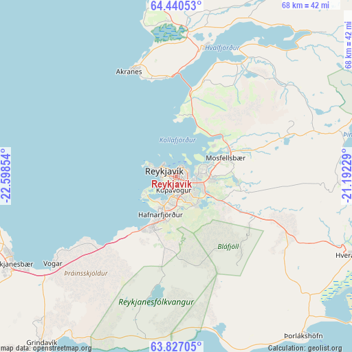
Reykjavík GPS coordinates[2]
64° 8' 7.728" North, 21° 53' 43.476" West
| Map corner | latitude | longitude |
|---|---|---|
| Upper-left | 64.44053°, | -22.59854° |
| Center: | 64.13548°, | -21.89541° |
| Lower-right: | 63.82705°, | -21.19229° |
| Map W x H: | 68.2×68.2 km | = 42.4×42.4mi |
| max Lat: | 66.15917° ⇑63% North |
| Reykjavík: | 64.13548° |
| min Lat: | ⇓37% South 63.44273° |
| min Long | Reykjavík | max Long |
| -23.99596° | -21.89541° | -13.68368° |
| W 41.3%⇐ | ⇒58.7% E |
Elevation
Elevation of Reykjavík is 37 m = 121 ft, and this is 15.7 m = 52 ft above average elevation for this country.
| Max E: |
105 m = 344 ft | 19.6% |
| Reykjavík | 37 m 121 ft | |
| Avg. | 21.3 m = 70 ft | |
Min E: |
1 m = 3 ft | 80.4% |
See also: Reykjavík elevation on elevation.city.
Geographical zone
Reykjavík is located in North temperate zone (between Tropic of Cancer and the Arctic Circle). Distance of this North polar circle is 270 km =167.8 mi to North.| Distance of | km | miles | from Reykjavík |
|---|---|---|---|
| North Pole | 2875.9 | 1787 | to North |
| Arctic Circle | 270 | 167.8 | to North |
| Tropic Cancer | 4525.3 | 2811.9 | to South |
| Equator | 7131.2 | 4431.1 | to South |


Nearby cities:
15 places around Reykjavík: (largest is in red/bold)
• Akranes
22.5 km =14 mi,  337°
337°
• Garðabær
5.4 km =3.4 mi,  194°
194°
• Garður
37.3 km =23.2 mi,  257°
257°
• Grundarhverfi
12 km =7.5 mi,  13°
13°
• Hafnarfjörður
7.9 km =4.9 mi,  195°
195°
• Hveragerði
37.6 km =23.4 mi,  113°
113°
• Keflavík
35.5 km =22.1 mi,  245°
245°
• Kópavogur
2.7 km =1.7 mi, 198°
• Mosfellsbær
10.1 km =6.3 mi,  69°
69°
• Reykjanesbær
35.8 km =22.2 mi,  244°
244°
• Sandgerði
41 km =25.5 mi, 254°
• Seltjarnarnes
5.2 km =3.2 mi,  292°
292°
• Vogar
29.3 km =18.2 mi,  234°
234°
• Álftanes
7.1 km =4.4 mi, 236°
• Þorlákshöfn
39.9 km =24.8 mi,  141°
141°
In other languages:
- In Spanish: Reikiavik
- In France: Reykjavik
- In Russian: Рейкьявик
- In Chinese: 雷克亞維克, 雷克雅維克
Sources, notices
• [Note1] Compared only with cities in Iceland existing in our database
• [Src1] Map data: © OpenStreetMap contributors (CC-BY-SA)
• [Src2] Other city data from geonames.org with taken over terms of usage.
• [Src3] Geographical zone / Annual Mean Temperature by Robert A. Rohde @ Wikipedia
