Álftanes geodata
Álftanes (Capital Region) is a populated place; located in Iceland in Atlantic/Reykjavik (GMT+0) time zone. With population of 2,392 people, there are 13 cities with bigger population in this country. Compared to other cities in Iceland, 67.4% of cities are located further ↑North; 71.7% of cities are located further →East and 100% of cities have higher elevation than Álftanes. Note1


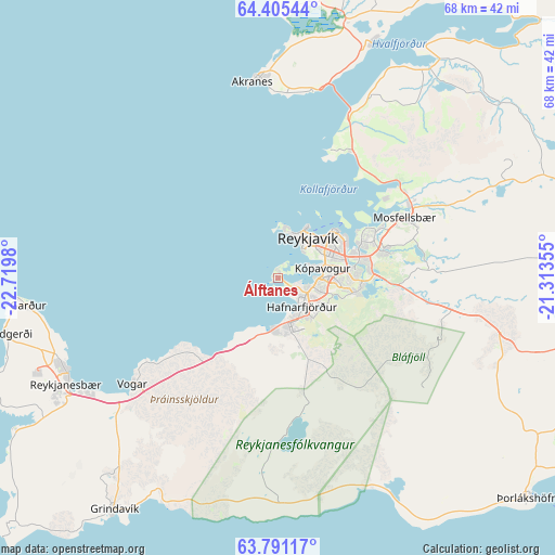
Álftanes GPS coordinates[2]
64° 6' 0" North, 22° 1' 0.012" West
| Map corner | latitude | longitude |
|---|---|---|
| Upper-left | 64.40544°, | -22.7198° |
| Center: | 64.1°, | -22.01667° |
| Lower-right: | 63.79117°, | -21.31355° |
| Map W x H: | 68.3×68.3 km | = 42.4×42.4mi |
| max Lat: | 66.15917° ⇑67.4% North |
| Álftanes: | 64.1° |
| min Lat: | ⇓32.6% South 63.44273° |
| min Long | Álftanes | max Long |
| -23.99596° | -22.01667° | -13.68368° |
| W 28.3%⇐ | ⇒71.7% E |
Elevation
Elevation of Álftanes is 1 m = 3 ft, and this is 20.3 m = 67 ft below average elevation for this country.
| Max E: |
105 m = 344 ft | 100% |
| Avg. | 21.3 m = 70 ft | |
| Álftanes | 1 m = 3 ft | |
Min E: |
1 m = 3 ft | 0% |
See also: Iceland elevation on elevation.city.
Geographical zone
Álftanes is located in North temperate zone (between Tropic of Cancer and the Arctic Circle). Distance of this North polar circle is 273.9 km =170.2 mi to North.| Distance of | km | miles | from Álftanes |
|---|---|---|---|
| North Pole | 2879.8 | 1789.4 | to North |
| Arctic Circle | 273.9 | 170.2 | to North |
| Tropic Cancer | 4521.3 | 2809.4 | to South |
| Equator | 7127.3 | 4428.7 | to South |


Nearby cities:
15 places around Álftanes: (largest is in red/bold)
• Akranes
24.8 km =15.4 mi,  353°
353°
• Garðabær
4.7 km =2.9 mi,  105°
105°
• Garður
30.8 km =19.1 mi,  262°
262°
• Grindavík
35.6 km =22.1 mi,  215°
215°
• Grundarhverfi
17.9 km =11.1 mi,  29°
29°
• Hafnarfjörður
5.3 km =3.3 mi,  133°
133°
• Keflavík
28.6 km =17.8 mi,  248°
248°
• Kópavogur
5.2 km =3.2 mi,  74°
74°
• Mosfellsbær
17.1 km =10.6 mi,  64°
64°
• Reykjanesbær
28.8 km =17.9 mi, 246°
• Reykjavík
7.1 km =4.4 mi, 56°
• Sandgerði
34.3 km =21.3 mi, 258°
• Seltjarnarnes
6 km =3.7 mi,  10°
10°
• Vogar
22.2 km =13.8 mi,  233°
233°
• Þorlákshöfn
41.1 km =25.5 mi, 131°
Sources, notices
• [Note1] Compared only with cities in Iceland existing in our database
• [Src1] Map data: © OpenStreetMap contributors (CC-BY-SA)
• [Src2] Other city data from geonames.org with taken over terms of usage.
• [Src3] Geographical zone / Annual Mean Temperature by Robert A. Rohde @ Wikipedia
