Vita geodata
Vita (Sicily) is a seat of a third-order administrative division; located in Italy in Europe/Rome (GMT+2) time zone. With population of 2,139 people, there are 3943 cities with bigger population in this country. Compared to other cities in Italy, 97.5% of cities are located further ↑North; 66.4% of cities are located further ←West and 74.2% of cities have lower elevation than Vita. Note1


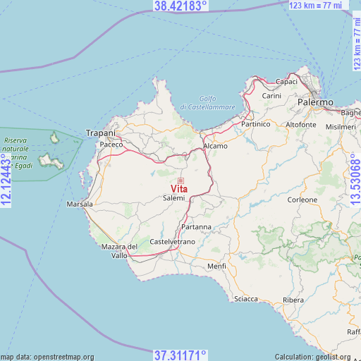
Vita GPS coordinates[2]
37° 52' 7.896" North, 12° 49' 39.18" East
| Map corner | latitude | longitude |
|---|---|---|
| Upper-left | 38.42183°, | 12.12443° |
| Center: | 37.86886°, | 12.82755° |
| Lower-right: | 37.31171°, | 13.53068° |
| Map W x H: | 123.4×123.4 km | = 76.7×76.7mi |
| max Lat: | 47.04031° ⇑97.5% North |
| Vita: | 37.86886° |
| min Lat: | ⇓2.5% South 35.50142° |
| min Long | Vita | max Long |
| 6.69888° | 12.82755° | 18.48682° |
| W 66.4%⇐ | ⇒33.6% E |
Elevation
Elevation of Vita is 441 m = 1447 ft, and this is 134.3 m = 441 ft above average elevation for this country.
| Max E: |
2085 m = 6841 ft | 25.8% |
| Vita | 441 m 1447 ft | |
| Avg. | 306.7 m = 1006 ft | |
Min E: |
-4 m = -13 ft | 74.2% |
See also: Italy elevation on elevation.city.
Geographical zone
Vita is located in North temperate zone (between Tropic of Cancer and the Arctic Circle). Distance of this Northern Tropic circle is 1604.7 km =997.1 mi to South.| Distance of | km | miles | from Vita |
|---|---|---|---|
| North Pole | 5796.4 | 3601.7 | to North |
| Arctic Circle | 3190.6 | 1982.5 | to North |
| Tropic Cancer | 1604.7 | 997.1 | to South |
| Equator | 4210.6 | 2616.3 | to South |


Nearby cities:
15 places around Vita: (largest is in red/bold)
• Alcamo
17.1 km =10.6 mi,  44°
44°
• Buseto Palizzolo
18.2 km =11.3 mi,  325°
325°
• Calatafimi
6 km =3.7 mi,  32°
32°
• Castellammare del Golfo
18.2 km =11.3 mi,  15°
15°
• Castelvetrano
21.1 km =13.1 mi,  188°
188°
• Fulgatore-Torretta
14.8 km =9.2 mi,  307°
307°
• Napola
21.9 km =13.6 mi, 308°
• Nuova Gibellina
7.8 km =4.8 mi,  151°
151°
• Nuovo Centro Urbano Poggioreale
21.7 km =13.5 mi,  122°
122°
• Partanna
16.7 km =10.4 mi,  161°
161°
• Salaparuta
20.3 km =12.6 mi,  127°
127°
• Salemi
5.6 km =3.5 mi,  200°
200°
• San Ciro-Ulmi-Filci
5.6 km =3.5 mi,  225°
225°
• Santa Ninfa
11.8 km =7.3 mi, 158°
• Sasi
6.5 km =4 mi,  55°
55°
Sources, notices
• [Note1] Compared only with cities in Italy existing in our database
• [Src1] Map data: © OpenStreetMap contributors (CC-BY-SA)
• [Src2] Other city data from geonames.org with taken over terms of usage.
• [Src3] Geographical zone / Annual Mean Temperature by Robert A. Rohde @ Wikipedia
