Salaparuta geodata
Salaparuta (Sicily) is a seat of a third-order administrative division; located in Italy in Europe/Rome (GMT+2) time zone. With population of 1,698 people, there are 4670 cities with bigger population in this country. Compared to other cities in Italy, 97.9% of cities are located further ↑North; 68.4% of cities are located further ←West and 57.9% of cities have higher elevation than Salaparuta. Note1


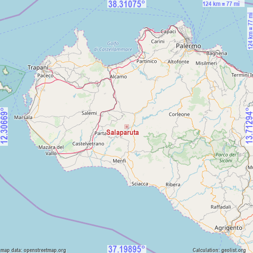
Salaparuta GPS coordinates[2]
37° 45' 24.984" North, 13° 0' 35.316" East
| Map corner | latitude | longitude |
|---|---|---|
| Upper-left | 38.31075°, | 12.30669° |
| Center: | 37.75694°, | 13.00981° |
| Lower-right: | 37.19895°, | 13.71294° |
| Map W x H: | 123.6×123.6 km | = 76.8×76.8mi |
| max Lat: | 47.04031° ⇑97.9% North |
| Salaparuta: | 37.75694° |
| min Lat: | ⇓2.1% South 35.50142° |
| min Long | Salaparuta | max Long |
| 6.69888° | 13.00981° | 18.48682° |
| W 68.4%⇐ | ⇒31.6% E |
Elevation
Elevation of Salaparuta is 180 m = 591 ft, and this is 126.7 m = 416 ft below average elevation for this country.
| Max E: |
2085 m = 6841 ft | 57.9% |
| Avg. | 306.7 m = 1006 ft | |
| Salaparuta | 180 m = 591 ft | |
Min E: |
-4 m = -13 ft | 42.1% |
See also: Italy elevation on elevation.city.
Geographical zone
Salaparuta is located in North temperate zone (between Tropic of Cancer and the Arctic Circle). Distance of this Northern Tropic circle is 1592.3 km =989.4 mi to South.| Distance of | km | miles | from Salaparuta |
|---|---|---|---|
| North Pole | 5808.9 | 3609.5 | to North |
| Arctic Circle | 3203 | 1990.3 | to North |
| Tropic Cancer | 1592.3 | 989.4 | to South |
| Equator | 4198.2 | 2608.6 | to South |


Nearby cities:
15 places around Salaparuta: (largest is in red/bold)
• Camporeale
16.4 km =10.2 mi,  29°
29°
• Castelvetrano
20.9 km =13 mi,  246°
246°
• Contessa Entellina
15.6 km =9.7 mi,  101°
101°
• Menfi
17.4 km =10.8 mi,  191°
191°
• Montevago
6.4 km =4 mi,  199°
199°
• Nuova Gibellina
13.5 km =8.4 mi,  294°
294°
• Nuovo Centro Urbano Poggioreale
2.4 km =1.5 mi,  71°
71°
• Partanna
11.1 km =6.9 mi, 252°
• Roccamena
15.6 km =9.7 mi,  54°
54°
• Salemi
19.4 km =12.1 mi, 291°
• Sambuca di Sicilia
14.8 km =9.2 mi,  141°
141°
• Santa Margherita di Belice
7.2 km =4.5 mi,  175°
175°
• Santa Ninfa
11.7 km =7.3 mi,  277°
277°
• Sasi
19.4 km =12.1 mi,  326°
326°
• Vita
20.3 km =12.6 mi,  307°
307°
Sources, notices
• [Note1] Compared only with cities in Italy existing in our database
• [Src1] Map data: © OpenStreetMap contributors (CC-BY-SA)
• [Src2] Other city data from geonames.org with taken over terms of usage.
• [Src3] Geographical zone / Annual Mean Temperature by Robert A. Rohde @ Wikipedia
