Tortolì geodata
Tortolì (Sardinia) is a seat of a third-order administrative division; located in Italy in Europe/Rome (GMT+2) time zone. With population of 7,830 people, there are 1245 cities with bigger population in this country. Compared to other cities in Italy, 88.5% of cities are located further ↑North; 71.3% of cities are located further →East and 89.6% of cities have higher elevation than Tortolì. Note1


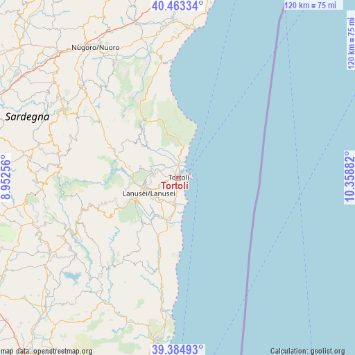
Tortolì GPS coordinates[2]
39° 55' 34.536" North, 9° 39' 20.484" East
| Map corner | latitude | longitude |
|---|---|---|
| Upper-left | 40.46334°, | 8.95256° |
| Center: | 39.92626°, | 9.65569° |
| Lower-right: | 39.38493°, | 10.35882° |
| Map W x H: | 119.9×119.9 km | = 74.5×74.5mi |
| max Lat: | 47.04031° ⇑88.5% North |
| Tortolì: | 39.92626° |
| min Lat: | ⇓11.5% South 35.50142° |
| min Long | Tortolì | max Long |
| 6.69888° | 9.65569° | 18.48682° |
| W 28.7%⇐ | ⇒71.3% E |
Elevation
Elevation of Tortolì is 19 m = 62 ft, and this is 287.7 m = 944 ft below average elevation for this country.
| Max E: |
2085 m = 6841 ft | 89.6% |
| Avg. | 306.7 m = 1006 ft | |
| Tortolì | 19 m = 62 ft | |
Min E: |
-4 m = -13 ft | 10.4% |
See also: Italy elevation on elevation.city.
Geographical zone
Tortolì is located in North temperate zone (between Tropic of Cancer and the Arctic Circle). Distance of this Northern Tropic circle is 1833.5 km =1139.3 mi to South.| Distance of | km | miles | from Tortolì |
|---|---|---|---|
| North Pole | 5567.7 | 3459.6 | to North |
| Arctic Circle | 2961.8 | 1840.4 | to North |
| Tropic Cancer | 1833.5 | 1139.3 | to South |
| Equator | 4439.4 | 2758.5 | to South |


Nearby cities:
15 places around Tortolì: (largest is in red/bold)
• Arbatax
4.3 km =2.7 mi,  77°
77°
• Arzana
11 km =6.8 mi,  264°
264°
• Bari Sardo
9.5 km =5.9 mi,  184°
184°
• Baunei
11.7 km =7.3 mi,  3°
3°
• Cardedu
14.6 km =9.1 mi,  189°
189°
• Elini
11 km =6.8 mi,  254°
254°
• Gairo Sant'Elena
15.4 km =9.6 mi,  236°
236°
• Girasole
2.9 km =1.8 mi,  8°
8°
• Ilbono
10.1 km =6.3 mi, 248°
• Lanusei
11.1 km =6.9 mi, 242°
• Loceri
9.8 km =6.1 mi,  219°
219°
• Lotzorai
4.8 km =3 mi, 7°
• Santa Maria Navarrese
7.5 km =4.7 mi,  18°
18°
• Triei
12.2 km =7.6 mi,  353°
353°
• Villagrande Strisaili
13 km =8.1 mi,  286°
286°
Sources, notices
• [Note1] Compared only with cities in Italy existing in our database
• [Src1] Map data: © OpenStreetMap contributors (CC-BY-SA)
• [Src2] Other city data from geonames.org with taken over terms of usage.
• [Src3] Geographical zone / Annual Mean Temperature by Robert A. Rohde @ Wikipedia
