Torregrotta geodata
Torregrotta (Sicily) is a seat of a third-order administrative division; located in Italy in Europe/Rome (GMT+2) time zone. With population of 7,324 people, there are 1330 cities with bigger population in this country. Compared to other cities in Italy, 95% of cities are located further ↑North; 89.9% of cities are located further ←West and 86.7% of cities have higher elevation than Torregrotta. Note1


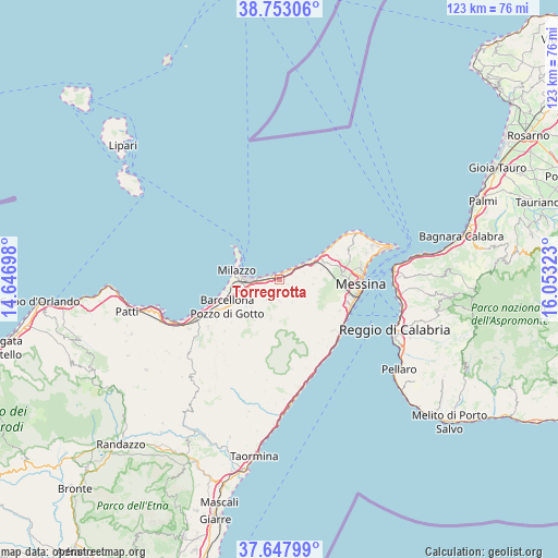
Torregrotta GPS coordinates[2]
38° 12' 9.432" North, 15° 21' 0.36" East
| Map corner | latitude | longitude |
|---|---|---|
| Upper-left | 38.75306°, | 14.64698° |
| Center: | 38.20262°, | 15.3501° |
| Lower-right: | 37.64799°, | 16.05323° |
| Map W x H: | 122.9×122.9 km | = 76.4×76.4mi |
| max Lat: | 47.04031° ⇑95% North |
| Torregrotta: | 38.20262° |
| min Lat: | ⇓5% South 35.50142° |
| min Long | Torregrotta | max Long |
| 6.69888° | 15.3501° | 18.48682° |
| W 89.9%⇐ | ⇒10.1% E |
Elevation
Elevation of Torregrotta is 26 m = 85 ft, and this is 280.7 m = 921 ft below average elevation for this country.
| Max E: |
2085 m = 6841 ft | 86.7% |
| Avg. | 306.7 m = 1006 ft | |
| Torregrotta | 26 m = 85 ft | |
Min E: |
-4 m = -13 ft | 13.3% |
See also: Italy elevation on elevation.city.
Geographical zone
Torregrotta is located in North temperate zone (between Tropic of Cancer and the Arctic Circle). Distance of this Northern Tropic circle is 1641.8 km =1020.2 mi to South.| Distance of | km | miles | from Torregrotta |
|---|---|---|---|
| North Pole | 5759.3 | 3578.7 | to North |
| Arctic Circle | 3153.4 | 1959.4 | to North |
| Tropic Cancer | 1641.8 | 1020.2 | to South |
| Equator | 4247.7 | 2639.4 | to South |


Nearby cities:
15 places around Torregrotta: (largest is in red/bold)
• Condrò
3.8 km =2.4 mi,  212°
212°
• Fondachello
1.6 km =1 mi,  19°
19°
• Giammoro
3.8 km =2.4 mi,  271°
271°
• Gualtieri Sicaminò
5.3 km =3.3 mi, 213°
• Monforte Marina
1.2 km =0.7 mi,  288°
288°
• Monforte San Giorgio
5.7 km =3.5 mi,  151°
151°
• Pace del Mela
4.6 km =2.9 mi,  236°
236°
• Roccavaldina
3 km =1.9 mi,  136°
136°
• Rometta Marea
6.2 km =3.9 mi,  57°
57°
• San Pier Marina
2.1 km =1.3 mi,  261°
261°
• San Pier Niceto
4.7 km =2.9 mi,  180°
180°
• Spadafora
3.6 km =2.2 mi,  50°
50°
• Valdina
2 km =1.2 mi,  120°
120°
• Venetico Marina
2.3 km =1.4 mi,  37°
37°
• Venetico Superiore
2.9 km =1.8 mi,  111°
111°
Sources, notices
• [Note1] Compared only with cities in Italy existing in our database
• [Src1] Map data: © OpenStreetMap contributors (CC-BY-SA)
• [Src2] Other city data from geonames.org with taken over terms of usage.
• [Src3] Geographical zone / Annual Mean Temperature by Robert A. Rohde @ Wikipedia
