Valdina geodata
Valdina (Sicily) is a seat of a third-order administrative division; located in Italy in Europe/Rome (GMT+2) time zone. With population of 356 people, there are 10456 cities with bigger population in this country. Compared to other cities in Italy, 95.1% of cities are located further ↑North; 90% of cities are located further ←West and 51.8% of cities have higher elevation than Valdina. Note1


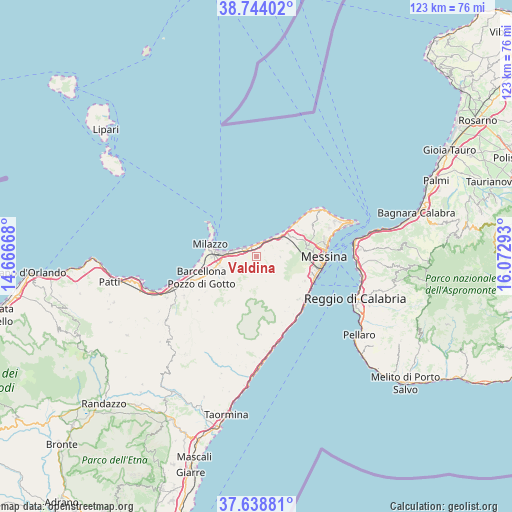
Valdina GPS coordinates[2]
38° 11' 36.636" North, 15° 22' 11.28" East
| Map corner | latitude | longitude |
|---|---|---|
| Upper-left | 38.74402°, | 14.66668° |
| Center: | 38.19351°, | 15.3698° |
| Lower-right: | 37.63881°, | 16.07293° |
| Map W x H: | 122.9×122.9 km | = 76.4×76.4mi |
| max Lat: | 47.04031° ⇑95.1% North |
| Valdina: | 38.19351° |
| min Lat: | ⇓4.9% South 35.50142° |
| min Long | Valdina | max Long |
| 6.69888° | 15.3698° | 18.48682° |
| W 90%⇐ | ⇒10% E |
Elevation
Elevation of Valdina is 223 m = 732 ft, and this is 83.7 m = 275 ft below average elevation for this country.
| Max E: |
2085 m = 6841 ft | 51.8% |
| Avg. | 306.7 m = 1006 ft | |
| Valdina | 223 m = 732 ft | |
Min E: |
-4 m = -13 ft | 48.2% |
See also: Italy elevation on elevation.city.
Geographical zone
Valdina is located in North temperate zone (between Tropic of Cancer and the Arctic Circle). Distance of this Northern Tropic circle is 1640.8 km =1019.5 mi to South.| Distance of | km | miles | from Valdina |
|---|---|---|---|
| North Pole | 5760.3 | 3579.3 | to North |
| Arctic Circle | 3154.5 | 1960.1 | to North |
| Tropic Cancer | 1640.8 | 1019.5 | to South |
| Equator | 4246.7 | 2638.8 | to South |


Nearby cities:
15 places around Valdina: (largest is in red/bold)
• Condrò
4.4 km =2.7 mi,  239°
239°
• Fondachello
2.8 km =1.7 mi,  334°
334°
• Monforte Marina
3.2 km =2 mi,  295°
295°
• Monforte San Giorgio
4.1 km =2.5 mi,  165°
165°
• Roccavaldina
1.2 km =0.7 mi,  162°
162°
• Rometta
4.7 km =2.9 mi,  123°
123°
• Rometta Marea
5.6 km =3.5 mi,  38°
38°
• San Pier Marina
3.9 km =2.4 mi,  280°
280°
• San Pier Niceto
4.1 km =2.5 mi,  205°
205°
• Saponara
5.6 km =3.5 mi,  91°
91°
• Scarcelli
5.6 km =3.5 mi,  76°
76°
• Spadafora
3.5 km =2.2 mi,  17°
17°
• Torregrotta
2 km =1.2 mi, 300°
• Venetico Marina
2.9 km =1.8 mi,  354°
354°
• Venetico Superiore
1 km =0.6 mi, 92°
Sources, notices
• [Note1] Compared only with cities in Italy existing in our database
• [Src1] Map data: © OpenStreetMap contributors (CC-BY-SA)
• [Src2] Other city data from geonames.org with taken over terms of usage.
• [Src3] Geographical zone / Annual Mean Temperature by Robert A. Rohde @ Wikipedia
