Sinopoli geodata
Sinopoli (Calabria) is a seat of a third-order administrative division; located in Italy in Europe/Rome (GMT+2) time zone. With population of 1,972 people, there are 4206 cities with bigger population in this country. Compared to other cities in Italy, 94.7% of cities are located further ↑North; 92.1% of cities are located further ←West and 77.8% of cities have lower elevation than Sinopoli. Note1
Administrative division(s):
- Level 1: Calabria
- Level 2: Provincia di Reggio Calabria
- Level 3: Sinopoli


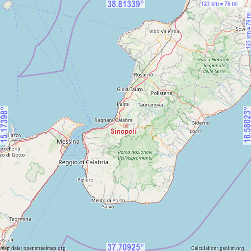
Sinopoli GPS coordinates[2]
38° 15' 48.312" North, 15° 52' 37.56" East
| Map corner | latitude | longitude |
|---|---|---|
| Upper-left | 38.81339°, | 15.17398° |
| Center: | 38.26342°, | 15.8771° |
| Lower-right: | 37.70925°, | 16.58023° |
| Map W x H: | 122.8×122.8 km | = 76.3×76.3mi |
| max Lat: | 47.04031° ⇑94.7% North |
| Sinopoli: | 38.26342° |
| min Lat: | ⇓5.3% South 35.50142° |
| min Long | Sinopoli | max Long |
| 6.69888° | 15.8771° | 18.48682° |
| W 92.1%⇐ | ⇒7.9% E |
Elevation
Elevation of Sinopoli is 490 m = 1608 ft, and this is 183.3 m = 601 ft above average elevation for this country.
| Max E: |
2085 m = 6841 ft | 22.2% |
| Sinopoli | 490 m 1608 ft | |
| Avg. | 306.7 m = 1006 ft | |
Min E: |
-4 m = -13 ft | 77.8% |
See also: Italy elevation on elevation.city.
Geographical zone
Sinopoli is located in North temperate zone (between Tropic of Cancer and the Arctic Circle). Distance of this Northern Tropic circle is 1648.6 km =1024.4 mi to South.| Distance of | km | miles | from Sinopoli |
|---|---|---|---|
| North Pole | 5752.6 | 3574.5 | to North |
| Arctic Circle | 3146.7 | 1955.3 | to North |
| Tropic Cancer | 1648.6 | 1024.4 | to South |
| Equator | 4254.5 | 2643.6 | to South |


Nearby cities:
15 places around Sinopoli: (largest is in red/bold)
• Bagnara Calabra
6.8 km =4.2 mi,  293°
293°
• Barritteri
7.8 km =4.8 mi,  341°
341°
• Castellace
8.1 km =5 mi,  42°
42°
• Ceramida-Pellegrina
5.8 km =3.6 mi,  309°
309°
• Cosoleto
4.6 km =2.9 mi,  74°
74°
• Delianuova
4.6 km =2.9 mi,  131°
131°
• Melicuccà
4.4 km =2.7 mi,  5°
5°
• Oppido Mamertina
9.9 km =6.2 mi, 70°
• San Procopio
2.4 km =1.5 mi,  29°
29°
• Sant'Eufemia d'Aspromonte
1.8 km =1.1 mi,  268°
268°
• Santa Cristina d'Aspromonte
8.2 km =5.1 mi,  96°
96°
• Scido
5.3 km =3.3 mi,  113°
113°
• Seminara
8.1 km =5 mi,  355°
355°
• Solano Inferiore
6.8 km =4.2 mi,  264°
264°
• Solano Superiore
6.9 km =4.3 mi, 259°
Sources, notices
• [Note1] Compared only with cities in Italy existing in our database
• [Src1] Map data: © OpenStreetMap contributors (CC-BY-SA)
• [Src2] Other city data from geonames.org with taken over terms of usage.
• [Src3] Geographical zone / Annual Mean Temperature by Robert A. Rohde @ Wikipedia
