Melicuccà geodata
Melicuccà (Calabria) is a seat of a third-order administrative division; located in Italy in Europe/Rome (GMT+2) time zone. With population of 953 people, there are 6849 cities with bigger population in this country. Compared to other cities in Italy, 94.6% of cities are located further ↑North; 92.1% of cities are located further ←West and 52.7% of cities have lower elevation than Melicuccà. Note1
Administrative division(s):
- Level 1: Calabria
- Level 2: Provincia di Reggio Calabria
- Level 3: Melicuccà


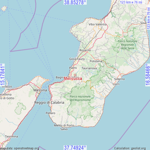
Melicuccà GPS coordinates[2]
38° 18' 11.196" North, 15° 52' 53.508" East
| Map corner | latitude | longitude |
|---|---|---|
| Upper-left | 38.85278°, | 15.17841° |
| Center: | 38.30311°, | 15.88153° |
| Lower-right: | 37.74924°, | 16.58466° |
| Map W x H: | 122.7×122.7 km | = 76.2×76.2mi |
| max Lat: | 47.04031° ⇑94.6% North |
| Melicuccà: | 38.30311° |
| min Lat: | ⇓5.4% South 35.50142° |
| min Long | Melicuccà | max Long |
| 6.69888° | 15.88153° | 18.48682° |
| W 92.1%⇐ | ⇒7.9% E |
Elevation
Elevation of Melicuccà is 251 m = 823 ft, and this is 55.7 m = 183 ft below average elevation for this country.
| Max E: |
2085 m = 6841 ft | 47.3% |
| Avg. | 306.7 m = 1006 ft | |
| Melicuccà | 251 m = 823 ft | |
Min E: |
-4 m = -13 ft | 52.7% |
See also: Italy elevation on elevation.city.
Geographical zone
Melicuccà is located in North temperate zone (between Tropic of Cancer and the Arctic Circle). Distance of this Northern Tropic circle is 1653 km =1027.1 mi to South.| Distance of | km | miles | from Melicuccà |
|---|---|---|---|
| North Pole | 5748.2 | 3571.8 | to North |
| Arctic Circle | 3142.3 | 1952.5 | to North |
| Tropic Cancer | 1653 | 1027.1 | to South |
| Equator | 4258.9 | 2646.4 | to South |


Nearby cities:
15 places around Melicuccà: (largest is in red/bold)
• Bagnara Calabra
6.8 km =4.2 mi,  255°
255°
• Barritteri
4.1 km =2.5 mi,  316°
316°
• Castellace
5.3 km =3.3 mi,  73°
73°
• Ceramida-Pellegrina
4.9 km =3 mi, 261°
• Cosoleto
5.1 km =3.2 mi,  127°
127°
• Delianuova
8.1 km =5 mi,  157°
157°
• Oppido Mamertina
9 km =5.6 mi,  96°
96°
• Palmi
6.8 km =4.2 mi,  337°
337°
• San Procopio
2.5 km =1.6 mi, 160°
• Sant'Eufemia d'Aspromonte
4.9 km =3 mi,  206°
206°
• Scido
7.9 km =4.9 mi,  145°
145°
• Seminara
3.8 km =2.4 mi, 344°
• Sinopoli
4.4 km =2.7 mi,  185°
185°
• Solano Inferiore
8.7 km =5.4 mi,  234°
234°
• Varapodio
9 km =5.6 mi,  80°
80°
Sources, notices
• [Note1] Compared only with cities in Italy existing in our database
• [Src1] Map data: © OpenStreetMap contributors (CC-BY-SA)
• [Src2] Other city data from geonames.org with taken over terms of usage.
• [Src3] Geographical zone / Annual Mean Temperature by Robert A. Rohde @ Wikipedia
