Santa Lucia del Mela geodata
Santa Lucia del Mela (Sicily) is a seat of a third-order administrative division; located in Italy in Europe/Rome (GMT+2) time zone. With population of 4,084 people, there are 2349 cities with bigger population in this country. Compared to other cities in Italy, 95.4% of cities are located further ↑North; 89.5% of cities are located further ←West and 53% of cities have higher elevation than Santa Lucia del Mela. Note1
Current local time in Santa Lucia del Mela:
11:18 PM, WednesdayDifference from your time zone: hours


Santa Lucia del Mela GPS coordinates[2]
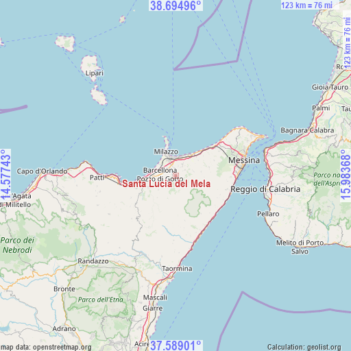
38° 8' 38.688" North, 15° 16' 49.98" East
| Map corner | latitude | longitude |
|---|---|---|
| Upper-left | 38.69496°, | 14.57743° |
| Center: | 38.14408°, | 15.28055° |
| Lower-right: | 37.58901°, | 15.98368° |
| Map W x H: | 123×123 km | = 76.4×76.4mi |
| max Lat: | 47.04031° ⇑95.4% North |
| Santa Lucia del Mela: | 38.14408° |
| min Lat: | ⇓4.6% South 35.50142° |
| min Long | Santa Lucia del | max Long |
| 6.69888° | 15.28055° | 18.48682° |
| W 89.5%⇐ | ⇒10.5% E |
Elevation
Elevation of Santa Lucia del Mela is 216 m = 709 ft, and this is 90.7 m = 298 ft below average elevation for this country.
| Max E: |
2085 m = 6841 ft | 53% |
| Avg. | 306.7 m = 1006 ft | |
| Santa Lucia del Mela | 216 m = 709 ft | |
Min E: |
-4 m = -13 ft | 47% |
See also: Italy elevation on elevation.city.
Geographical zone
Santa Lucia del Mela is located in North temperate zone (between Tropic of Cancer and the Arctic Circle). Distance of this Northern Tropic circle is 1635.3 km =1016.1 mi to South.| Distance of | km | miles | from Santa Lucia del Mela |
|---|---|---|---|
| North Pole | 5765.8 | 3582.7 | to North |
| Arctic Circle | 3159.9 | 1963.5 | to North |
| Tropic Cancer | 1635.3 | 1016.1 | to South |
| Equator | 4241.2 | 2635.4 | to South |


Nearby cities:
15 places around Santa Lucia del Mela: (largest is in red/bold)
• Acquaficara
6.6 km =4.1 mi,  255°
255°
• Archi
5.7 km =3.5 mi,  354°
354°
• Barcellona Pozzo di Gotto
5.8 km =3.6 mi,  274°
274°
• Castroreale
8 km =5 mi,  230°
230°
• Condrò
5.2 km =3.2 mi,  50°
50°
• Giammoro
7 km =4.3 mi,  18°
18°
• Gualtieri Sicaminò
3.8 km =2.4 mi,  57°
57°
• La Gala
5.2 km =3.2 mi,  236°
236°
• Merì
3.7 km =2.3 mi,  312°
312°
• Pace del Mela
4.6 km =2.9 mi,  29°
29°
• Protonotaro
8.1 km =5 mi,  251°
251°
• San Filippo del Mela
3 km =1.9 mi, 347°
• San Paolo-Cannistrà
4.3 km =2.7 mi, 253°
• San Pier Marina
7.4 km =4.6 mi, 32°
• San Pier Niceto
6.3 km =3.9 mi,  73°
73°
Sources, notices
• [Note1] Compared only with cities in Italy existing in our database
• [Src1] Map data: © OpenStreetMap contributors (CC-BY-SA)
• [Src2] Other city data from geonames.org with taken over terms of usage.
• [Src3] Geographical zone / Annual Mean Temperature by Robert A. Rohde @ Wikipedia
