Parenti geodata
Parenti (Calabria) is a seat of a third-order administrative division; located in Italy in Europe/Rome (GMT+2) time zone. With population of 1,546 people, there are 5019 cities with bigger population in this country. Compared to other cities in Italy, 92% of cities are located further ↑North; 95.9% of cities are located further ←West and 94.3% of cities have lower elevation than Parenti. Note1


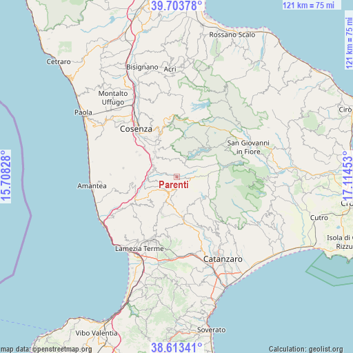
Parenti GPS coordinates[2]
39° 9' 38.556" North, 16° 24' 41.04" East
| Map corner | latitude | longitude |
|---|---|---|
| Upper-left | 39.70378°, | 15.70828° |
| Center: | 39.16071°, | 16.4114° |
| Lower-right: | 38.61341°, | 17.11453° |
| Map W x H: | 121.2×121.2 km | = 75.3×75.3mi |
| max Lat: | 47.04031° ⇑92% North |
| Parenti: | 39.16071° |
| min Lat: | ⇓8% South 35.50142° |
| min Long | Parenti | max Long |
| 6.69888° | 16.4114° | 18.48682° |
| W 95.9%⇐ | ⇒4.1% E |
Elevation
Elevation of Parenti is 849 m = 2785 ft, and this is 542.3 m = 1779 ft above average elevation for this country.
| Max E: |
2085 m = 6841 ft | 5.7% |
| Parenti | 849 m 2785 ft | |
| Avg. | 306.7 m = 1006 ft | |
Min E: |
-4 m = -13 ft | 94.3% |
See also: Italy elevation on elevation.city.
Geographical zone
Parenti is located in North temperate zone (between Tropic of Cancer and the Arctic Circle). Distance of this Northern Tropic circle is 1748.3 km =1086.3 mi to South.| Distance of | km | miles | from Parenti |
|---|---|---|---|
| North Pole | 5652.8 | 3512.5 | to North |
| Arctic Circle | 3046.9 | 1893.3 | to North |
| Tropic Cancer | 1748.3 | 1086.3 | to South |
| Equator | 4354.3 | 2705.6 | to South |


Nearby cities:
15 places around Parenti: (largest is in red/bold)
• Aprigliano
10.9 km =6.8 mi,  326°
326°
• Belsito
10.8 km =6.7 mi,  279°
279°
• Bianchi
6.7 km =4.2 mi,  180°
180°
• Calvisi
9.8 km =6.1 mi,  247°
247°
• Carpanzano
9.3 km =5.8 mi,  261°
261°
• Cellara
9.2 km =5.7 mi,  314°
314°
• Colosimi
4.7 km =2.9 mi,  192°
192°
• Figline Vegliaturo
10 km =6.2 mi,  315°
315°
• Mangone
8.3 km =5.2 mi, 305°
• Marzi
9.1 km =5.7 mi, 276°
• Pedivigliano
10.8 km =6.7 mi,  238°
238°
• Rogliano
8.4 km =5.2 mi, 283°
• Santo Stefano di Rogliano
8.6 km =5.3 mi,  294°
294°
• Soveria Mannelli
9.7 km =6 mi,  197°
197°
• Vallegianno
10.1 km =6.3 mi,  295°
295°
Sources, notices
• [Note1] Compared only with cities in Italy existing in our database
• [Src1] Map data: © OpenStreetMap contributors (CC-BY-SA)
• [Src2] Other city data from geonames.org with taken over terms of usage.
• [Src3] Geographical zone / Annual Mean Temperature by Robert A. Rohde @ Wikipedia
