Noto geodata
Noto (Sicily) is a seat of a third-order administrative division; located in Italy in Europe/Rome (GMT+2) time zone. With population of 18,421 people, there are 478 cities with bigger population in this country. Compared to other cities in Italy, 99.8% of cities are located further ↑North; 87.7% of cities are located further ←West and 63.4% of cities have higher elevation than Noto. Note1


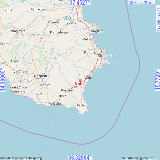
Noto GPS coordinates[2]
36° 53' 32.784" North, 15° 4' 11.172" East
| Map corner | latitude | longitude |
|---|---|---|
| Upper-left | 37.4527°, | 14.36665° |
| Center: | 36.89244°, | 15.06977° |
| Lower-right: | 36.32804°, | 15.7729° |
| Map W x H: | 125.1×125.1 km | = 77.7×77.7mi |
| max Lat: | 47.04031° ⇑99.8% North |
| Noto: | 36.89244° |
| min Lat: | ⇓0.2% South 35.50142° |
| min Long | Noto | max Long |
| 6.69888° | 15.06977° | 18.48682° |
| W 87.7%⇐ | ⇒12.3% E |
Elevation
Elevation of Noto is 138 m = 453 ft, and this is 168.7 m = 553 ft below average elevation for this country.
| Max E: |
2085 m = 6841 ft | 63.4% |
| Avg. | 306.7 m = 1006 ft | |
| Noto | 138 m = 453 ft | |
Min E: |
-4 m = -13 ft | 36.6% |
See also: Italy elevation on elevation.city.
Geographical zone
Noto is located in North temperate zone (between Tropic of Cancer and the Arctic Circle). Distance of this Northern Tropic circle is 1496.1 km =929.6 mi to South.| Distance of | km | miles | from Noto |
|---|---|---|---|
| North Pole | 5905 | 3669.2 | to North |
| Arctic Circle | 3299.1 | 2050 | to North |
| Tropic Cancer | 1496.1 | 929.6 | to South |
| Equator | 4102.1 | 2548.9 | to South |


Nearby cities:
15 places around Noto: (largest is in red/bold)
• Arenella
21.1 km =13.1 mi,  54°
54°
• Avola
6.4 km =4 mi,  73°
73°
• Campanella-Gianforma
21.3 km =13.2 mi,  280°
280°
• Canicattini Bagni
15.5 km =9.6 mi,  358°
358°
• Cassibile
15.1 km =9.4 mi, 50°
• Fanusa
23.6 km =14.7 mi, 52°
• Floridia
22.5 km =14 mi,  19°
19°
• Fontane Bianche
14.9 km =9.3 mi,  56°
56°
• Gallina
10.4 km =6.5 mi, 63°
• Ispica
18.8 km =11.7 mi,  231°
231°
• Lido di Noto
5.4 km =3.4 mi,  133°
133°
• Pachino
19.8 km =12.3 mi,  174°
174°
• Rosolini
13.2 km =8.2 mi, 233°
• Santa Maria del Focallo
22.7 km =14.1 mi,  209°
209°
• Solarino
23.7 km =14.7 mi,  10°
10°
Sources, notices
• [Note1] Compared only with cities in Italy existing in our database
• [Src1] Map data: © OpenStreetMap contributors (CC-BY-SA)
• [Src2] Other city data from geonames.org with taken over terms of usage.
• [Src3] Geographical zone / Annual Mean Temperature by Robert A. Rohde @ Wikipedia
