Campanella-Gianforma geodata
Campanella-Gianforma (Sicily) is a populated place; located in Italy in Europe/Rome (GMT+2) time zone. With population of 1,750 people, there are 4574 cities with bigger population in this country. Compared to other cities in Italy, 99.8% of cities are located further ↑North; 85.8% of cities are located further ←West and 76.7% of cities have lower elevation than Campanella-Gianforma. Note1
Current local time in Campanella-Gianforma:
08:21 PM, WednesdayDifference from your time zone: hours


Campanella-Gianforma GPS coordinates[2]
36° 55' 34.68" North, 14° 50' 0.96" East
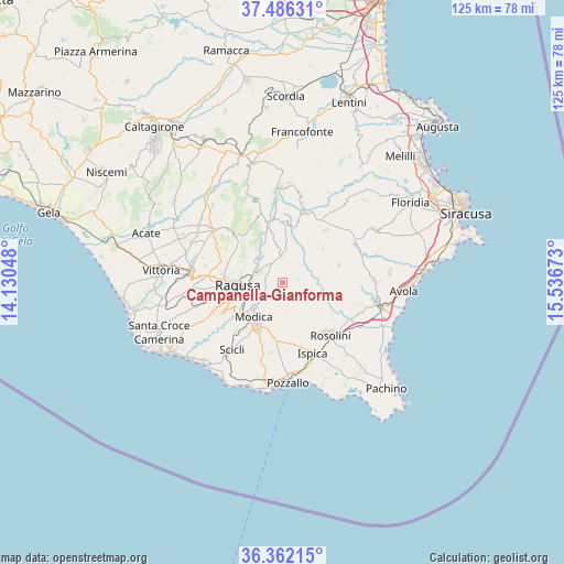
| Map corner | latitude | longitude |
|---|---|---|
| Upper-left | 37.48631°, | 14.13048° |
| Center: | 36.9263°, | 14.8336° |
| Lower-right: | 36.36215°, | 15.53673° |
| Map W x H: | 125×125 km | = 77.7×77.7mi |
| max Lat: | 47.04031° ⇑99.8% North |
| Campanella-Gianforma: | 36.9263° |
| min Lat: | ⇓0.2% South 35.50142° |
| min Long | Campanella-Gian | max Long |
| 6.69888° | 14.8336° | 18.48682° |
| W 85.8%⇐ | ⇒14.2% E |
Elevation
Elevation of Campanella-Gianforma is 476 m = 1562 ft, and this is 169.3 m = 555 ft above average elevation for this country.
| Max E: |
2085 m = 6841 ft | 23.3% |
| Campanella-Gianforma | 476 m 1562 ft | |
| Avg. | 306.7 m = 1006 ft | |
Min E: |
-4 m = -13 ft | 76.7% |
See also: Italy elevation on elevation.city.
Geographical zone
Campanella-Gianforma is located in North temperate zone (between Tropic of Cancer and the Arctic Circle). Distance of this Northern Tropic circle is 1499.9 km =932 mi to South.| Distance of | km | miles | from Campanella-Gianforma |
|---|---|---|---|
| North Pole | 5901.2 | 3666.8 | to North |
| Arctic Circle | 3295.4 | 2047.7 | to North |
| Tropic Cancer | 1499.9 | 932 | to South |
| Equator | 4105.8 | 2551.2 | to South |


Nearby cities:
15 places around Campanella-Gianforma: (largest is in red/bold)
• Buccheri
22.1 km =13.7 mi,  4°
4°
• Buscemi
18.3 km =11.4 mi,  14°
14°
• Chiaramonte Gulfi
16.4 km =10.2 mi,  314°
314°
• Comiso
20.3 km =12.6 mi,  277°
277°
• Giarratana
13.9 km =8.6 mi,  345°
345°
• Ispica
16.8 km =10.4 mi,  157°
157°
• Modica
10 km =6.2 mi,  221°
221°
• Monterosso Almo
19.1 km =11.9 mi,  341°
341°
• Noto
21.3 km =13.2 mi,  100°
100°
• Palazzolo Acreide
16.5 km =10.3 mi,  22°
22°
• Pozzallo
21.8 km =13.5 mi,  176°
176°
• Ragusa
9.7 km =6 mi,  269°
269°
• Rosolini
15.7 km =9.8 mi,  138°
138°
• Scicli
19.1 km =11.9 mi, 217°
• Villaggio Gulfi
18.3 km =11.4 mi, 312°
Sources, notices
• [Note1] Compared only with cities in Italy existing in our database
• [Src1] Map data: © OpenStreetMap contributors (CC-BY-SA)
• [Src2] Other city data from geonames.org with taken over terms of usage.
• [Src3] Geographical zone / Annual Mean Temperature by Robert A. Rohde @ Wikipedia
