Mosorrofa geodata
Mosorrofa (Calabria) is a populated place; located in Italy in Europe/Rome (GMT+2) time zone. With population of 1,830 people, there are 4447 cities with bigger population in this country. Compared to other cities in Italy, 95.7% of cities are located further ↑North; 91.3% of cities are located further ←West and 65.3% of cities have lower elevation than Mosorrofa. Note1
Administrative division(s):
- Level 1: Calabria
- Level 2: Provincia di Reggio Calabria
- Level 3: Reggio Calabria


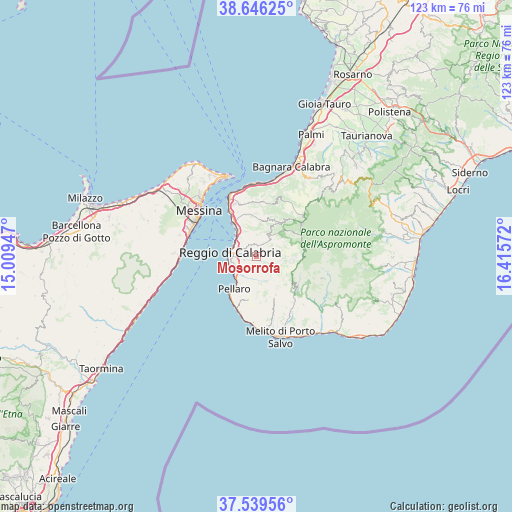
Mosorrofa GPS coordinates[2]
38° 5' 42" North, 15° 42' 45.324" East
| Map corner | latitude | longitude |
|---|---|---|
| Upper-left | 38.64625°, | 15.00947° |
| Center: | 38.095°, | 15.71259° |
| Lower-right: | 37.53956°, | 16.41572° |
| Map W x H: | 123.1×123.1 km | = 76.5×76.5mi |
| max Lat: | 47.04031° ⇑95.7% North |
| Mosorrofa: | 38.095° |
| min Lat: | ⇓4.3% South 35.50142° |
| min Long | Mosorrofa | max Long |
| 6.69888° | 15.71259° | 18.48682° |
| W 91.3%⇐ | ⇒8.7% E |
Elevation
Elevation of Mosorrofa is 346 m = 1135 ft, and this is 39.3 m = 129 ft above average elevation for this country.
| Max E: |
2085 m = 6841 ft | 34.7% |
| Mosorrofa | 346 m 1135 ft | |
| Avg. | 306.7 m = 1006 ft | |
Min E: |
-4 m = -13 ft | 65.3% |
See also: Italy elevation on elevation.city.
Geographical zone
Mosorrofa is located in North temperate zone (between Tropic of Cancer and the Arctic Circle). Distance of this Northern Tropic circle is 1629.8 km =1012.7 mi to South.| Distance of | km | miles | from Mosorrofa |
|---|---|---|---|
| North Pole | 5771.3 | 3586.1 | to North |
| Arctic Circle | 3165.4 | 1966.9 | to North |
| Tropic Cancer | 1629.8 | 1012.7 | to South |
| Equator | 4235.8 | 2632 | to South |


Nearby cities:
15 places around Mosorrofa: (largest is in red/bold)
• Bagaladi
12.3 km =7.6 mi,  128°
128°
• Calanna
10 km =6.2 mi,  5°
5°
• Cardeto
4.8 km =3 mi,  104°
104°
• Colelli
13 km =8.1 mi,  3°
3°
• Fossato Ionico-Fossatello-San Luca Marcelluzzo
10.4 km =6.5 mi,  154°
154°
• Laganadi
9.1 km =5.7 mi,  15°
15°
• Motta San Giovanni
9.4 km =5.8 mi,  179°
179°
• Pavigliana
1.5 km =0.9 mi,  28°
28°
• Pellaro
10.3 km =6.4 mi,  212°
212°
• Reggio Calabria
4.8 km =3 mi,  290°
290°
• Sambatello
9.5 km =5.9 mi,  349°
349°
• Sant'Alessio in Aspromonte
9.4 km =5.8 mi, 24°
• Santo Stefano in Aspromonte
10.7 km =6.6 mi,  39°
39°
• Terreti
2.9 km =1.8 mi,  358°
358°
• Trunca
6.3 km =3.9 mi, 148°
Sources, notices
• [Note1] Compared only with cities in Italy existing in our database
• [Src1] Map data: © OpenStreetMap contributors (CC-BY-SA)
• [Src2] Other city data from geonames.org with taken over terms of usage.
• [Src3] Geographical zone / Annual Mean Temperature by Robert A. Rohde @ Wikipedia
