Sant'Alessio in Aspromonte geodata
Sant'Alessio in Aspromonte (Calabria) is a seat of a third-order administrative division; located in Italy in Europe/Rome (GMT+2) time zone. With population of 322 people, there are 10591 cities with bigger population in this country. Compared to other cities in Italy, 95.2% of cities are located further ↑North; 91.5% of cities are located further ←West and 83.5% of cities have lower elevation than Sant'Alessio in Aspromonte. Note1
Administrative division(s):
- Level 1: Calabria
- Level 2: Provincia di Reggio Calabria
- Level 3: Sant'Alessio in Aspromonte
Current local time in Sant'Alessio in Aspromonte:
08:28 PM, WednesdayDifference from your time zone: hours


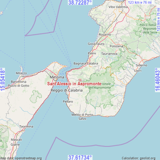
Sant'Alessio in Aspromonte GPS coordinates[2]
38° 10' 19.92" North, 15° 45' 26.28" East
| Map corner | latitude | longitude |
|---|---|---|
| Upper-left | 38.72287°, | 15.05418° |
| Center: | 38.1722°, | 15.7573° |
| Lower-right: | 37.61734°, | 16.46043° |
| Map W x H: | 122.9×122.9 km | = 76.4×76.4mi |
| max Lat: | 47.04031° ⇑95.2% North |
| Sant'Alessio in Aspromonte: | 38.1722° |
| min Lat: | ⇓4.8% South 35.50142° |
| min Long | Sant'Alessio in | max Long |
| 6.69888° | 15.7573° | 18.48682° |
| W 91.5%⇐ | ⇒8.5% E |
Elevation
Elevation of Sant'Alessio in Aspromonte is 580 m = 1903 ft, and this is 273.3 m = 897 ft above average elevation for this country.
| Max E: |
2085 m = 6841 ft | 16.5% |
| Sant'Alessio in Aspromonte | 580 m 1903 ft | |
| Avg. | 306.7 m = 1006 ft | |
Min E: |
-4 m = -13 ft | 83.5% |
See also: Italy elevation on elevation.city.
Geographical zone
Sant'Alessio in Aspromonte is located in North temperate zone (between Tropic of Cancer and the Arctic Circle). Distance of this Northern Tropic circle is 1638.4 km =1018.1 mi to South.| Distance of | km | miles | from Sant'Alessio in Aspromonte |
|---|---|---|---|
| North Pole | 5762.7 | 3580.8 | to North |
| Arctic Circle | 3156.8 | 1961.5 | to North |
| Tropic Cancer | 1638.4 | 1018.1 | to South |
| Equator | 4244.4 | 2637.3 | to South |


Nearby cities:
15 places around Sant'Alessio in Aspromonte: (largest is in red/bold)
• Calanna
3.3 km =2.1 mi,  294°
294°
• Campo Calabro
9.9 km =6.2 mi,  299°
299°
• Cardeto
9.8 km =6.1 mi,  175°
175°
• Colelli
5.4 km =3.4 mi,  324°
324°
• Fiumara
7.2 km =4.5 mi,  308°
308°
• Laganadi
1.4 km =0.9 mi,  277°
277°
• Mosorrofa
9.4 km =5.8 mi,  204°
204°
• Pavigliana
7.9 km =4.9 mi, 203°
• Sambatello
5.7 km =3.5 mi, 277°
• San Nicola
7.1 km =4.4 mi, 308°
• San Roberto
4.7 km =2.9 mi,  336°
336°
• Santo Stefano in Aspromonte
2.9 km =1.8 mi,  96°
96°
• Scilla
9.5 km =5.9 mi, 339°
• Solano Superiore
9.6 km =6 mi,  22°
22°
• Terreti
7 km =4.3 mi,  215°
215°
Sources, notices
• [Note1] Compared only with cities in Italy existing in our database
• [Src1] Map data: © OpenStreetMap contributors (CC-BY-SA)
• [Src2] Other city data from geonames.org with taken over terms of usage.
• [Src3] Geographical zone / Annual Mean Temperature by Robert A. Rohde @ Wikipedia
