Maratea geodata
Maratea (Basilicate) is a seat of a third-order administrative division; located in Italy in Europe/Rome (GMT+2) time zone. With population of 2,715 people, there are 3293 cities with bigger population in this country. Compared to other cities in Italy, 87.9% of cities are located further ↑North; 91.3% of cities are located further ←West and 58.1% of cities have higher elevation than Maratea. Note1


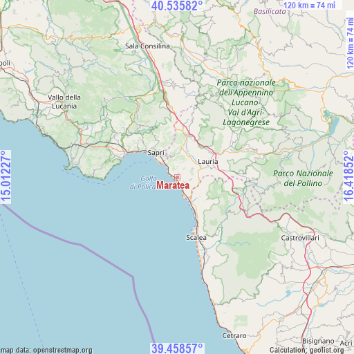
Maratea GPS coordinates[2]
39° 59' 57.552" North, 15° 42' 55.404" East
| Map corner | latitude | longitude |
|---|---|---|
| Upper-left | 40.53582°, | 15.01227° |
| Center: | 39.99932°, | 15.71539° |
| Lower-right: | 39.45857°, | 16.41852° |
| Map W x H: | 119.8×119.8 km | = 74.4×74.4mi |
| max Lat: | 47.04031° ⇑87.9% North |
| Maratea: | 39.99932° |
| min Lat: | ⇓12.1% South 35.50142° |
| min Long | Maratea | max Long |
| 6.69888° | 15.71539° | 18.48682° |
| W 91.3%⇐ | ⇒8.7% E |
Elevation
Elevation of Maratea is 179 m = 587 ft, and this is 127.7 m = 419 ft below average elevation for this country.
| Max E: |
2085 m = 6841 ft | 58.1% |
| Avg. | 306.7 m = 1006 ft | |
| Maratea | 179 m = 587 ft | |
Min E: |
-4 m = -13 ft | 41.9% |
See also: Italy elevation on elevation.city.
Geographical zone
Maratea is located in North temperate zone (between Tropic of Cancer and the Arctic Circle). Distance of this Northern Tropic circle is 1841.6 km =1144.3 mi to South.| Distance of | km | miles | from Maratea |
|---|---|---|---|
| North Pole | 5559.6 | 3454.6 | to North |
| Arctic Circle | 2953.7 | 1835.3 | to North |
| Tropic Cancer | 1841.6 | 1144.3 | to South |
| Equator | 4447.5 | 2763.5 | to South |


Nearby cities:
15 places around Maratea: (largest is in red/bold)
• Aieta
12.2 km =7.6 mi,  130°
130°
• Lagonegro
14.8 km =9.2 mi,  15°
15°
• Lauria
11.7 km =7.3 mi,  63°
63°
• Massa
3.1 km =1.9 mi,  124°
124°
• Nemoli
10.4 km =6.5 mi,  43°
43°
• Praia a Mare
13.1 km =8.1 mi,  153°
153°
• Rivello
9.5 km =5.9 mi, 22°
• S.Maria Fiumicello
11.4 km =7.1 mi,  71°
71°
• Sapri
11 km =6.8 mi,  319°
319°
• Torraca
14.1 km =8.8 mi,  331°
331°
• Tortora
10 km =6.2 mi, 130°
• Tortora Marina
9.7 km =6 mi, 151°
• Trecchina
5.9 km =3.7 mi, 59°
• Vibonati
15.8 km =9.8 mi,  314°
314°
• Villammare
13.5 km =8.4 mi, 310°
Sources, notices
• [Note1] Compared only with cities in Italy existing in our database
• [Src1] Map data: © OpenStreetMap contributors (CC-BY-SA)
• [Src2] Other city data from geonames.org with taken over terms of usage.
• [Src3] Geographical zone / Annual Mean Temperature by Robert A. Rohde @ Wikipedia
