Lagonegro geodata
Lagonegro (Basilicate) is a seat of a third-order administrative division; located in Italy in Europe/Rome (GMT+2) time zone. With population of 5,056 people, there are 1936 cities with bigger population in this country. Compared to other cities in Italy, 86.9% of cities are located further ↑North; 91.6% of cities are located further ←West and 89.5% of cities have lower elevation than Lagonegro. Note1


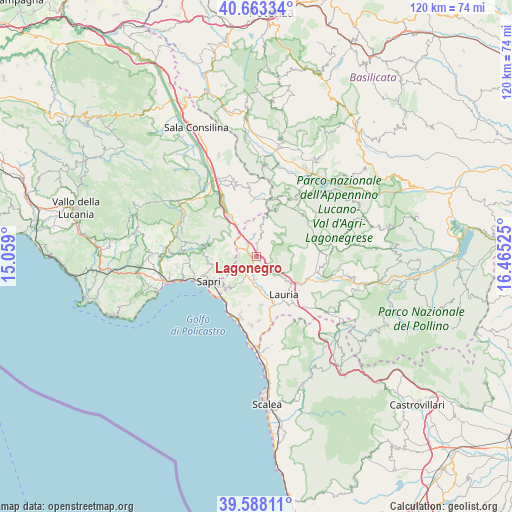
Lagonegro GPS coordinates[2]
40° 7' 40.26" North, 15° 45' 43.632" East
| Map corner | latitude | longitude |
|---|---|---|
| Upper-left | 40.66334°, | 15.059° |
| Center: | 40.12785°, | 15.76212° |
| Lower-right: | 39.58811°, | 16.46525° |
| Map W x H: | 119.6×119.6 km | = 74.3×74.3mi |
| max Lat: | 47.04031° ⇑86.9% North |
| Lagonegro: | 40.12785° |
| min Lat: | ⇓13.1% South 35.50142° |
| min Long | Lagonegro | max Long |
| 6.69888° | 15.76212° | 18.48682° |
| W 91.6%⇐ | ⇒8.4% E |
Elevation
Elevation of Lagonegro is 707 m = 2320 ft, and this is 400.3 m = 1313 ft above average elevation for this country.
| Max E: |
2085 m = 6841 ft | 10.5% |
| Lagonegro | 707 m 2320 ft | |
| Avg. | 306.7 m = 1006 ft | |
Min E: |
-4 m = -13 ft | 89.5% |
See also: Italy elevation on elevation.city.
Geographical zone
Lagonegro is located in North temperate zone (between Tropic of Cancer and the Arctic Circle). Distance of this Northern Tropic circle is 1855.9 km =1153.2 mi to South.| Distance of | km | miles | from Lagonegro |
|---|---|---|---|
| North Pole | 5545.3 | 3445.7 | to North |
| Arctic Circle | 2939.4 | 1826.5 | to North |
| Tropic Cancer | 1855.9 | 1153.2 | to South |
| Equator | 4461.8 | 2772.4 | to South |


Nearby cities:
15 places around Lagonegro: (largest is in red/bold)
• Casalbuono
11.5 km =7.1 mi,  326°
326°
• Casaletto Spartano
12.3 km =7.6 mi,  282°
282°
• Cessuta
14.1 km =8.8 mi,  7°
7°
• Lauria
11.1 km =6.9 mi,  144°
144°
• Maratea
14.8 km =9.2 mi,  195°
195°
• Nemoli
7.4 km =4.6 mi,  154°
154°
• Rivello
5.5 km =3.4 mi,  183°
183°
• S.Maria Fiumicello
12.6 km =7.8 mi, 147°
• Sapri
12.5 km =7.8 mi,  241°
241°
• Tardiano
14.1 km =8.8 mi,  354°
354°
• Torraca
10.9 km =6.8 mi,  260°
260°
• Tortorella
13.3 km =8.3 mi, 276°
• Trecchina
11.4 km =7.1 mi,  174°
174°
• Vibonati
15.5 km =9.6 mi, 258°
• Villammare
15.4 km =9.6 mi,  248°
248°
Sources, notices
• [Note1] Compared only with cities in Italy existing in our database
• [Src1] Map data: © OpenStreetMap contributors (CC-BY-SA)
• [Src2] Other city data from geonames.org with taken over terms of usage.
• [Src3] Geographical zone / Annual Mean Temperature by Robert A. Rohde @ Wikipedia
