Linguaglossa geodata
Linguaglossa (Sicily) is a seat of a third-order administrative division; located in Italy in Europe/Rome (GMT+2) time zone. With population of 5,234 people, there are 1865 cities with bigger population in this country. Compared to other cities in Italy, 97.6% of cities are located further ↑North; 88.4% of cities are located further ←West and 82.1% of cities have lower elevation than Linguaglossa. Note1


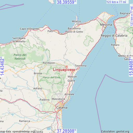
Linguaglossa GPS coordinates[2]
37° 50' 32.748" North, 15° 8' 15.864" East
| Map corner | latitude | longitude |
|---|---|---|
| Upper-left | 38.39559°, | 14.43462° |
| Center: | 37.84243°, | 15.13774° |
| Lower-right: | 37.28508°, | 15.84087° |
| Map W x H: | 123.5×123.5 km | = 76.7×76.7mi |
| max Lat: | 47.04031° ⇑97.6% North |
| Linguaglossa: | 37.84243° |
| min Lat: | ⇓2.4% South 35.50142° |
| min Long | Linguaglossa | max Long |
| 6.69888° | 15.13774° | 18.48682° |
| W 88.4%⇐ | ⇒11.6% E |
Elevation
Elevation of Linguaglossa is 556 m = 1824 ft, and this is 249.3 m = 818 ft above average elevation for this country.
| Max E: |
2085 m = 6841 ft | 17.9% |
| Linguaglossa | 556 m 1824 ft | |
| Avg. | 306.7 m = 1006 ft | |
Min E: |
-4 m = -13 ft | 82.1% |
See also: Italy elevation on elevation.city.
Geographical zone
Linguaglossa is located in North temperate zone (between Tropic of Cancer and the Arctic Circle). Distance of this Northern Tropic circle is 1601.8 km =995.3 mi to South.| Distance of | km | miles | from Linguaglossa |
|---|---|---|---|
| North Pole | 5799.4 | 3603.6 | to North |
| Arctic Circle | 3193.5 | 1984.3 | to North |
| Tropic Cancer | 1601.8 | 995.3 | to South |
| Equator | 4207.7 | 2614.5 | to South |


Nearby cities:
15 places around Linguaglossa: (largest is in red/bold)
• Calatabiano
8.5 km =5.3 mi,  106°
106°
• Castiglione di Sicilia
4.6 km =2.9 mi,  341°
341°
• Chianchitta-Pallio
10.4 km =6.5 mi,  103°
103°
• Chianchitta-Trappitello
10 km =6.2 mi, 98°
• Fiumefreddo Sicilia
8.5 km =5.3 mi,  132°
132°
• Francavilla di Sicilia
6.6 km =4.1 mi,  0°
0°
• Gaggi
7.6 km =4.7 mi,  75°
75°
• Graniti
9.3 km =5.8 mi,  55°
55°
• Moio Alcantara
10 km =6.2 mi,  310°
310°
• Motta Camastra
6.4 km =4 mi,  26°
26°
• Nunziata
9.8 km =6.1 mi,  162°
162°
• Pasteria-Lapide
8.7 km =5.4 mi, 114°
• Piedimonte Etneo
5.2 km =3.2 mi,  140°
140°
• Santa Venera-Portosalvo
7.7 km =4.8 mi, 156°
• Solicchiata
6.8 km =4.2 mi,  290°
290°
Sources, notices
• [Note1] Compared only with cities in Italy existing in our database
• [Src1] Map data: © OpenStreetMap contributors (CC-BY-SA)
• [Src2] Other city data from geonames.org with taken over terms of usage.
• [Src3] Geographical zone / Annual Mean Temperature by Robert A. Rohde @ Wikipedia
