Lago geodata
Lago (Calabria) is a seat of a third-order administrative division; located in Italy in Europe/Rome (GMT+2) time zone. With population of 1,250 people, there are 5787 cities with bigger population in this country. Compared to other cities in Italy, 91.9% of cities are located further ↑North; 94% of cities are located further ←West and 82.3% of cities have lower elevation than Lago. Note1


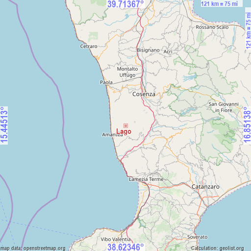
Lago GPS coordinates[2]
39° 10' 14.448" North, 16° 8' 53.7" East
| Map corner | latitude | longitude |
|---|---|---|
| Upper-left | 39.71367°, | 15.44513° |
| Center: | 39.17068°, | 16.14825° |
| Lower-right: | 38.62346°, | 16.85138° |
| Map W x H: | 121.2×121.2 km | = 75.3×75.3mi |
| max Lat: | 47.04031° ⇑91.9% North |
| Lago: | 39.17068° |
| min Lat: | ⇓8.1% South 35.50142° |
| min Long | Lago | max Long |
| 6.69888° | 16.14825° | 18.48682° |
| W 94%⇐ | ⇒6% E |
Elevation
Elevation of Lago is 559 m = 1834 ft, and this is 252.3 m = 828 ft above average elevation for this country.
| Max E: |
2085 m = 6841 ft | 17.7% |
| Lago | 559 m 1834 ft | |
| Avg. | 306.7 m = 1006 ft | |
Min E: |
-4 m = -13 ft | 82.3% |
See also: Italy elevation on elevation.city.
Geographical zone
Lago is located in North temperate zone (between Tropic of Cancer and the Arctic Circle). Distance of this Northern Tropic circle is 1749.5 km =1087.1 mi to South.| Distance of | km | miles | from Lago |
|---|---|---|---|
| North Pole | 5651.7 | 3511.8 | to North |
| Arctic Circle | 3045.8 | 1892.6 | to North |
| Tropic Cancer | 1749.5 | 1087.1 | to South |
| Equator | 4355.4 | 2706.3 | to South |


Nearby cities:
15 places around Lago: (largest is in red/bold)
• Aiello Calabro
6.1 km =3.8 mi,  165°
165°
• Altilia
10.1 km =6.3 mi,  116°
116°
• Amantea
8 km =5 mi,  232°
232°
• Belmonte Calabro
5.7 km =3.5 mi,  262°
262°
• Cleto
9 km =5.6 mi, 174°
• Domanico
7.2 km =4.5 mi,  44°
44°
• Fiumefreddo Bruzio
9.9 km =6.2 mi,  317°
317°
• Grimaldi
8.2 km =5.1 mi,  113°
113°
• Longobardi
7.7 km =4.8 mi,  304°
304°
• Malito
8.6 km =5.3 mi,  99°
99°
• Marina
7.1 km =4.4 mi, 263°
• San Biase
7.8 km =4.8 mi, 320°
• San Pietro in Amantea
4.9 km =3 mi,  219°
219°
• Scaro-Reggio-Scornavacca-Vardano
9.9 km =6.2 mi,  310°
310°
• Serra d'Aiello
9.2 km =5.7 mi,  192°
192°
Sources, notices
• [Note1] Compared only with cities in Italy existing in our database
• [Src1] Map data: © OpenStreetMap contributors (CC-BY-SA)
• [Src2] Other city data from geonames.org with taken over terms of usage.
• [Src3] Geographical zone / Annual Mean Temperature by Robert A. Rohde @ Wikipedia
