Amantea geodata
Amantea (Calabria) is a seat of a third-order administrative division; located in Italy in Europe/Rome (GMT+2) time zone. With population of 8,917 people, there are 1065 cities with bigger population in this country. Compared to other cities in Italy, 92.1% of cities are located further ↑North; 93.3% of cities are located further ←West and 92.6% of cities have higher elevation than Amantea. Note1


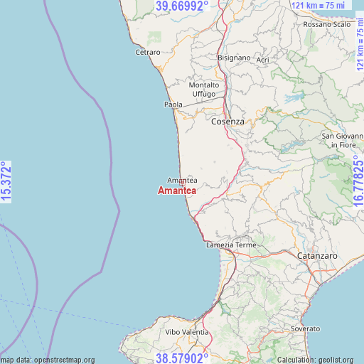
Amantea GPS coordinates[2]
39° 7' 35.688" North, 16° 4' 30.432" East
| Map corner | latitude | longitude |
|---|---|---|
| Upper-left | 39.66992°, | 15.372° |
| Center: | 39.12658°, | 16.07512° |
| Lower-right: | 38.57902°, | 16.77825° |
| Map W x H: | 121.3×121.3 km | = 75.4×75.4mi |
| max Lat: | 47.04031° ⇑92.1% North |
| Amantea: | 39.12658° |
| min Lat: | ⇓7.9% South 35.50142° |
| min Long | Amantea | max Long |
| 6.69888° | 16.07512° | 18.48682° |
| W 93.3%⇐ | ⇒6.7% E |
Elevation
Elevation of Amantea is 13 m = 43 ft, and this is 293.7 m = 964 ft below average elevation for this country.
| Max E: |
2085 m = 6841 ft | 92.6% |
| Avg. | 306.7 m = 1006 ft | |
| Amantea | 13 m = 43 ft | |
Min E: |
-4 m = -13 ft | 7.4% |
See also: Italy elevation on elevation.city.
Geographical zone
Amantea is located in North temperate zone (between Tropic of Cancer and the Arctic Circle). Distance of this Northern Tropic circle is 1744.5 km =1084 mi to South.| Distance of | km | miles | from Amantea |
|---|---|---|---|
| North Pole | 5656.6 | 3514.8 | to North |
| Arctic Circle | 3050.7 | 1895.6 | to North |
| Tropic Cancer | 1744.5 | 1084 | to South |
| Equator | 4350.5 | 2703.3 | to South |


Nearby cities:
15 places around Amantea: (largest is in red/bold)
• Aiello Calabro
7.8 km =4.8 mi,  97°
97°
• Belmonte Calabro
4.2 km =2.6 mi,  8°
8°
• Campora San Giovanni
6.8 km =4.2 mi,  164°
164°
• Cleto
8.2 km =5.1 mi,  119°
119°
• Corica
4.8 km =3 mi,  166°
166°
• Fiumefreddo Bruzio
12.1 km =7.5 mi,  358°
358°
• Lago
8 km =5 mi,  52°
52°
• Longobardi
9.3 km =5.8 mi, 359°
• Marina
4.2 km =2.6 mi,  349°
349°
• Nocera Terinese
12.9 km =8 mi,  142°
142°
• San Biase
10.9 km =6.8 mi, 6°
• San Mango d'Aquino
12.5 km =7.8 mi,  126°
126°
• San Pietro in Amantea
3.4 km =2.1 mi,  70°
70°
• Scaro-Reggio-Scornavacca-Vardano
11.4 km =7.1 mi, 353°
• Serra d'Aiello
6 km =3.7 mi, 132°
Sources, notices
• [Note1] Compared only with cities in Italy existing in our database
• [Src1] Map data: © OpenStreetMap contributors (CC-BY-SA)
• [Src2] Other city data from geonames.org with taken over terms of usage.
• [Src3] Geographical zone / Annual Mean Temperature by Robert A. Rohde @ Wikipedia
